Territory of Arizona extends from the 109th degree, west longitude, to the Great Colorado, and from 31 28', north latitude to the thirty-seventh parallel. The States immediately adjoining it and lying without the limits named, are: on the west California and Nevada, on the south the State of Sonora, Mexico, on the east the Territory of New Mexico, and on the north State of Nevada and the Territory of Utah. It is the extreme southwestern corner of the United States and comprises 113,947 square miles. The general features of the country are full of variety, and abound in striking and picturesque contrasts. At once the fairest and the wildest, the most picturesque and the most fruitful scenes are to be found on the elevated plateau, of which Arizona mainly consists. In the northern portion, especially, are found tremendous chasms, gloomy canyons and narrow, but fruitful, valleys, hemmed in by majestic mountains. The same diversified scenery, the same mingled grandeur and beauty are found in every part of the Territory in a more or less marked and striking degree, and it would be hard to find, on this or any other continent, a range of country of equal extent, where so many grand and beautiful "bits" of landscape tempt the brush of the artist. When, in addition to this, it is remembered that, over all this sublimity and beauty of scenery, there is a cloudless sky, illuminated by a sun of undimmed brilliancy, it may safely be asserted that Arizona has a claim that cannot well be disputed to being the Paradise of America.
But the idea must not be entertained that Arizona is merely a land where the eye is pleased with beauty and the other senses gratified with peculiar delights. It is not simply a locus-eater's land, " where it is always afternoon," and devoid of those inducements to labor and industry which allure and incite men to activity in the pursuit of wealth. Its mountains are not merely picturesque and awe-inspiring in their grandeur; they abound in the mineral wealth from which so many vast fortunes have been already drawn, and from which so many more are destined to be derived. The vast plains, covered with a rich herbage, support countless flocks and herds which are the source of untold wealth, and the cultivated plains and valleys, blessed by a climate unsurpassed on earth, produce every conceivable cereal and fruit required for man's support or the gratification of his palate. In short, if there be any drawback mixed up with the unquestionable and self-evident attraction which Arizona holds forth to the man who is in search either of wealth, health or a home,. it has not been found, up to date.
It will be of interest to run over, very cursorily, and without any pretense of elaborate or detailed description, the salient features of the Territory. Its greatest length, from north to south, may be roughly stated at 400 miles, while, from east to west, it measures approximately 350 miles. As has been already said, it is mostly an elevated plateau or mesa a very vast table-land rising to a height of from 5,000 to 7,000 feet above sea-level in the northern part. Towards the southwest corner it slopes down to the level of the shore. The highest point of the entire Territory is the summit of the extinct volcano, San Francisco, which reaches an elevation of nearly 8,000 feet above the level of the sea. It is visible over a radius of 200 miles, and, during at least half the year, the summit and sides of the defunct crater are covered with snow, forming one of the grandest sights imaginable, as it towers in its unspotted garb of heaven's ermine, and in solitary majesty over the adjoining scenery, “monarch," in verity, as well as appearance, "of all it surveys."
The Rivers of Arizona
The grandest of all the rivers
of Arizona, whether we consider its volume, its length or the extent, of
country which it drains, is, beyond all question, the Colorado of the West.
Indeed, except the Columbia, it is by far the largest river that flows into
the Pacific Ocean. It takes its rise in the Wind River chain of the Rocky mountains,
about 12,000 feet above the sea level, and, until its junction with the
Grand River in Southeastern Utah, it is known
as the Green River. From that point until it debouches into the
Gulf of California, it is called the
Colorado. Its course is southwesterly until it reaches the mouth of the
Virgin, when it turns its course almost due south and continues to flow in
the same direction until it reaches the Gulf. Its other principal tributary
is the San Juan, which joins it above the entrance of the Grand Canyon. The
whole length of the river is over 1,500 miles, and the area drained by it is
computed to be larger than New England, Pennsylvania and Virginia combined.
It is not a good stream for commercial purposes on account of its channel
continually shifting, although it is navigable for boats of light draught
for about 600 miles. It drains the whole Territory of
Arizona, though within the limits of Territory it receives only two tributaries
of any great size the Little Colorado and the Gila.
The Colorado Plateau is in the extreme
northern part of the Territory, and varies in elevation, as already stated,
from 5,000 to 7,000 feet. Besides the giant peak of San Francisco, there are
the Bradshaw and Mogollon ranges of mountains rising from this vast mesa
with an abruptness which, while it redeems the scene from monotony, does not
interfere with the unity or rather continuity of the vast tableland. Besides
these there are numerous detached spurs of the monarch peaks, striking off
on either side like the ribs of some mammoth vertebrate. The intercostal
spaces are filled by verdant and fertile valleys, widening, in many
instances, into grassy plains, where armies of cowboys raise herds of cattle
to supply the wants of a great proportion of the world's markets. This vast
plateau is watered or drained, if you will by numerous streams, the chief of
which are the Colorado of the West, the Colorado Chiquito, the Gila and the
Verde.
THE
GRAND CANYON
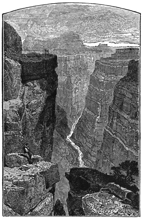
The Grand Canon of the Colorado, 400 miles in length, is the most remarkable
feature of the whole course of the river. This stupendous gorge, cut out by
the Colorado, through the plateau, in the course of pointless ages is one of
the grandest sights on earth, and dwarfs, by comparison, all the other
natural wonders which attract the tourist, the descriptive writer and the
artist. Let the reader imagine, if he can, a cleft in the volcanic rock over
400 miles in length, with walls varying from 1,000 to 6,000 feet in height,
descending sheer to the bed of the river, carved into all manner of
fantastic shapes, either by the action of the river, ages ago, or by the
storms of centuries. Imagine, at the bottom of this awful chasm, the great
river dashing along in billows and foam, through its rocky channel, which it
is still busied in deepening, being joined, here and there on, by
tributaries, dashing down the clefts they have hollowed out for themselves
in imitation of the sovereign stream. Imagine the varied effects of light
and shadow which must result from such an association of precipitous height
and varied outline. When all this is done the human imagination, however
vivid, will utterly fail, as human powers of description will, to give
anything like an adequate idea of the Grand Canon of the Colorado. Even when
seen with the eye, it seems too stupendous to be grasped by the mind, and
too sublime for description. The Little Colorado, or Colorado Chiquito, as
the Mexicans call it, rises in the Sierra Blanco, and follows an almost
uniform northwesterly course of 200 miles until it joins the Great Colorado
near Grand Canon. Its tributaries are taking them in the order in which they
join it the Zuni from New Mexico, the Rio Puerco likewise from New Mexico,
the Leroux Fork, Chevelon's Fork (both small mountain streams) and the
Moencopy.
The Rio Puerco, about ten miles above its junction with the Little Colorado, is joined by the Lithodendron (Stone-tree) Creek on the banks of which is one of the most wonderful natural phenomena to be found in the world, in the Petrified Forest. The Forest is several miles in extent and consists of trees of the cone-bearing variety literally "turned into stone." All over the ground, between the trunks of the trees, are strewn branches and leaves in a state of petrification and, here and there, bodies of birds and animals are said to be found in the same condition. Some of the trees are of vast size and are not unlike, in many respects, the Sequoia Gigantea, of California.
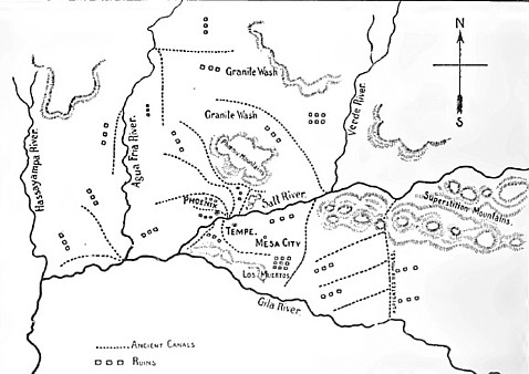
The Gila, the largest tributary of the Great Colorado and the next to it in size of the rivers of Arizona, rises in the eastern part of the Mogollon mountains. It flows in a westerly course, though with many windings from the time it enters the Territory at the New Mexico line until it joins the Great Colorado at Yuma. It receives the Rio San Francisco from the Sierra Natanes, the Bonita and Eagle creeks from the Sierra Blanco, all three clear and rapid mountain streams. From the point where the Bonita joins it, the Gila flows through the Pueblo Viejo, a beautiful valley nearly 40 miles in length, and varying from 2 to 4 in width. The Rio del Sur, an underground river, joins the Gila near the town of Solomonville, and the San Carlos, a large stream from the valley of the same name falls into it just before it enters the canyon which it has cut through several rocky ranges which cross its course soon after it leaves the Pueblo Viejo. After emerging from this canon, a few miles above the town of Florence, it enters on the wide and unbroken plain which stretches from there to the Colorado River, the destination of the Gila.
One tributary of the Gila, to wit, the Salt River, is large enough to merit special mention by itself. It is formed by the union of the Black and White rivers in the Mogollon mountains, these rivers receiving many tributary creek's, from their rise in the Sierra Blanca until they join to form the Salt River. Like the Gila, the Salt River passes through a picturesque canon in which it receives several tributaries such as the Tonto, Cherry and Cibicu creeks, and after a course of about 200 miles joins the Gila below Phoenix, losing its name and individuality in those of that river. The canon cut by the Salt River, through the same range of mountains which the Gila pierces, is longer, and, if possible, even more picturesque, as regards scenery, than that made by the river to which it is tributary. A somewhat curious, though not unparalleled, circumstance is that, though the Salt River is called a tributary of the Gila, it is. as a matter of fact, a considerably larger river, and should, by rights, absorb the name of the latter, instead of vice versa.
Its own principal feeder is the Rio Verde which rises in the Chino Valley, in the Colorado Plateau between the Juniper and Bill Williams' mountains. Into it flows Granite Creek, on which the city of Prescott stands, and it picks up numerous mountain streams from the Black Hills, San Francisco peak and the Mazatzal range. It is a beautiful stream teeming with fish, and passing through many rich and fertile valleys in its course.
A tributary of the Gila which calls for special notice is the Santa Cruz, which, rising in the Patagonia mountains, in the extreme south of Pima County, crosses the Mexican line, and, after running for several miles through Sonora, turns back and flows due north to the city of Tucson, whence it takes a northwesterly course and joins the Gila. The peculiar thing about this river is, that its channel being through a loose sort of gravel, it disappears, here and there in its course, to reappear at some other point, and wherever it shows on the surface, it has been made available for irrigation with the most gratifying results. The Agua Fria, which, rising ten miles east of Prescott, circles around the northern part of the Sierra Prietas, flows parallel to the Rio Verde, and, after making a trip underground, joins the Gila at Big Bend. Its whole course is about 120 miles. A number of minor streams and mountain creeks (whose name is legion for they are many) might be enumerated, but sufficient has been said to show that Arizona is a well favored land in this regard, and that while she has some unproductive spots, and some desert tracts, she has, nevertheless, within her boundaries, immense stretches of the most fertile soil, blessed with abundance of that life-giving and fertilizing element which was the first thing the Creator provided for Eden, and which has rendered so many portions of Arizona, in all respects, "like unto a garden which the Lord hath blessed."
Return
to The Arizona Page:
Arizona Gold Rush Mining History