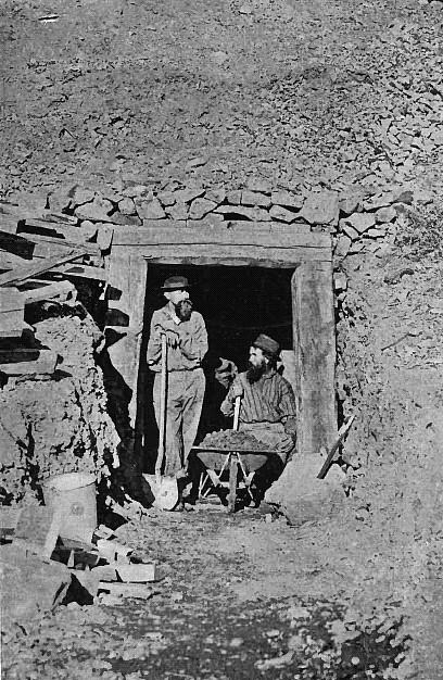
One of the best known Oregon gold mining areas is the already famous Eastern Oregon Gold Field, of which Baker City is the center and metropolis. The district holds nearly 15,000 Square Miles of Rich Placers and Ore-Beds, and represents great chances for Prospectors. Stretching from the northeastern part of Wallowa County down into the northern end of Malheur and Harney counties, and from the Snake river far over on the tributaries of the John Day, and including all of Baker and a large part of Grant and Union counties, this vast mineral belt extends through two degrees of latitude and longitude. That is, it is about 120 miles square, and has an area of 14,400 square miles—or within a trifle of as much as Massachusetts, Rhode Island and Connecticut, all combined. It is traversed in every direction by spurs of the picturesque Blue Mountains from 6,000 to 9,600 feet high, and is watered by innumerable bold streams like the Wallowa, Imnaha, Grand Ronde, Powder and Burnt rivers, and the tributaries of the John Day and Malheur. There are immense forests of valuable timber, the valleys are exhaustless in fertility, and the climate is mild and healthful. But the one all-overshadowing fact, to which the region owes its first settlement and growth, and will owe its future progress and celebrity, is that investigation so far indicates that there is virtually no limit to its rich and varied mineral resources.
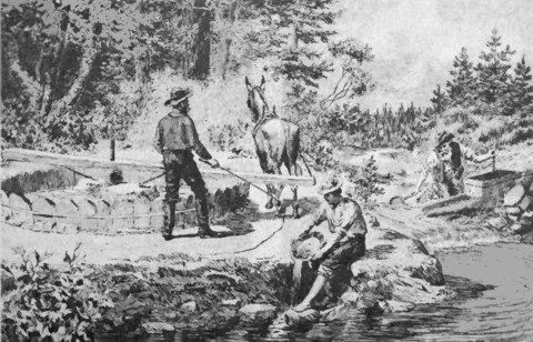
Its every peak and foothill seem ribbed with royal ore, and its every valley a mighty deposit of golden sands; while silver, copper, lead and iron abound, and precious stones are found in some localities. It has produced untold millions of dollars in gold that in earlier days went to San Francisco to swell the reports of California's yield. Grant County has turned out over $5,000,000 of placer gold nuggets alone, and Baker, county's aggregate production of quartz and placer gold has certainly not been less than $12,000,000; and both are in the infancy of their mining greatness.
According to the report of the United States mint director, Oregon produced $1,690,950 of gold in 1893, of which $1,377,-479 came from Baker, Grant, Union and Malheur counties; Baker county alone furnishing $728,496. The output of these four counties in 1896 was at least $1,500,000; and this year, with enlarged plants and improved methods of treatment, it will reach close to $2,500,000. The whole region is rich in resources and products now, and assured of being incalculably richer as its mighty stores of hidden wealth are opened up, and the boundless opportunities it offers for speedy fortune become known.
Almost exactly in the geographical center of this grand empire of present and prospective mines, has arisen, as its natural capital and emporium, the handsome and flourishing little city, that bears the name of Oregon's soldier-statesman, General E. D. Baker, the hero and victim of Ball's Bluff. It is the county-seat of Baker county, which, with an area of 3,500 square miles, is larger than Rhode Island and Delaware put together. It is 422 miles, a little south of east from Portland, on the line of the Oregon Railway and Navigation Company, which runs 69 miles diagonally through the county, from northwest to southeast. The altitude of the city is 3,440 feet above the level of the sea. The climate is unsurpassable in all the qualities that are conducive to health and vigor. Though there is considerable snowfall, the winters are comparatively mild, and cattle run on the ranges all the year without feeding or care. The summer heat is never oppressive, and the nights are always delightfully cool. The valleys, for from 50 to 75 miles on every side of Baker City, are fertile in soil, yielding abundant crops of all the leading grains, grasses and vegetables, and fine fruit is grown in the lower altitudes.
All kinds of livestock do well, with no care or attention, and thousands of cattle, horses, hogs and sheep are raised. Everywhere, north, west and northwest of the city, are forests of magnificent timber for all mining and building purposes, consisting generally of giant pine, fir, spruce and tamarack. To the east and southeast, the timber is less abundant. The whole region is watered by mountain streams, Powder river running through the very heart of Baker City. The Sumpter Valley railroad, 30 miles long, connects the place with all the agricultural, pastoral and mineral regions lying west and southwest of it, for fully 100 miles; and well-constructed wagon roads, recently finished, bring it the trade of a large part of Baker, Union and Grant counties, and the northern end of Malheur and Harney counties. It is the depot and supply-point for all the mines and mining camps of the entire region, including something like a half-hundred districts.
With such a position and such surroundings. Baker City could not have failed to thrive, as few western towns have done in recent years. In spite of the general dullness and depression, it has steadily grown and prospered. It has nearly trebled its population since the census of 1890. rising from 2,600 then to something like 7,000 now. The gold yield of its immediately tributary territory has increased, within the last four years, from $600,000, to fully $1,500,000, a year. Its farming and stock-growing interests have greatly advanced, and its business in every line has kept step to the music of a double-quick forward march. Its streets are broad and well kept, and many of its public and private buildings would be creditable to a city of 25,000 people. Several of its business blocks have cost from $15,000 to $40,000 each. Its churches and public schools are handsome and tasteful. It has a number of flourishing manufacturing establishments, including a mill that turns out 80,000 feet of lumber a day, waterworks, gas and electric light plants, a street railway, and two live daily newspapers and three weeklies. The Oregon Railway and Navigation Company has a large and conveniently arranged depot, a fine stone-and-iron warehouse and extensive stockyards. There is no busier or more prosperous little city in the west, and its future is radiant with promise, for every day is adding to the number and productiveness of the great mines on which, at last, all its progress and prosperity depend.
Return
to The Oregon History Page:
Oregon Gold Rush History