THE CEMENT-DEPOSITS
In the ordinary course of professional work I examined the two most
important of these deposits, at Kintore and Kanowna, respectively. Since
then a third formation of a similar character has been opened up, also at
Kanowna. This I happened to see when in the stages of early development, and
before it had been extensively exploited. The deposit of cement at Kintore
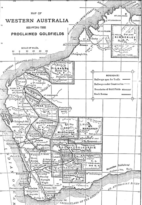
was one of the earliest worked. It is situated 23 miles northwest of
Coolgardie, on the road to Menzies. The West Australian Proprietary Cement
Company mined the ground with a success which was short lived, because of
the restricted quantity of material rich enough to pay the high costs of
treatment. In four months, 7335 ounces of
gold were obtained by treating
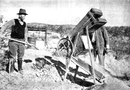
4115 tons in a stamp mill, supplemented by cyanide-vats. Enough work has
been done to disclose the character of the deposit. Representative sections
have been obtained in the open cuts. Under a thin covering of sand and dust
there occurs a bed of kaolin, ranging from a couple of inches to a foot in
thickness ; and this overlies from 15 inches to 2 feet of "sand-rock," which
in turn gives place to the gold-bearing cement, which has an average
thickness of 20 feet. The last lies directly upon an irregular surface of
decomposed granite. The several layers composing the deposit are separated
by seams of pipe-clay, which, like the kaolin, are simply the product of the
decomposition of the constituents of the granite, particularly the feldspar.
The sand-rock may be described as a coarse, incompletely consolidated
sandstone or grit, consisting mainly of iron-stained particles of quartz,
loosely cemented. The cement has a bluish-gray tinge, owing to the play of
light on the quartz fragments. This, too, is not quite compacted, since
fractures through the material do not break across the pebbles, which are
harder than the clay binding them together.
In this respect the cement differs, for example, from the Witwatersrand gold deposit "blanket," to which it has been compared. From a distance, the cement looks like a coarse sandstone and exhibits a rough-joint structure. The materials of which it has been made up have undergone incipient sizing, so that different layers of varying coarseness are distinguishable. The bed-rock is granite, so softened by decomposition as to be mistaken by the miners for a part of the alluvial deposit. It is kaolinized to a depth which the neighboring mine-shafts prove to reach a maximum of 30 feet. The surface on which the cement lies is marked by pot-holes having a maximum depth of 2 feet and a diameter reaching to 3 feet. These holes are filled with cement, which is usually poor save at the rims, where some of the richest mill-stuff has been obtained. All the members of the deposit, from surface to bed-rock, contain some gold, the kaolin being the poorest. The cement itself attains a maximum thickness of 5 feet. The richest parts occur in lateral embranchments from the main body of the deposit. The kaolin has become hardened and dried. It breaks like shale; and its true character is obscured by the down-filtering of red sand through cracks reaching to the soil overhead.
The deposit extends through a number of mining claims and has been traced for a length of three-quarters of a mile. At the east end it begins as a narrow neck about 15 feet wide, and then enlarges steadily to 100 feet. Occasional bulges increase this width to a maximum of 250 feet. At the edge it gives place, as it thins out, to 2 or 3 feet of ironstone gravel, carrying 3 or 4 dwts. of gold per ton. The best part, economically, of the deposit lies in the Ophelia and Hilton claims, which, it will be noted, are situated at the lower end of the basin. The bed-rock rises westward at the rate of 15 feet per thousand. This fact suggested that the origin of the gold-bearing cement was to be found in the reefs which were being profitably mined by the Sugar Loaf Company. The workings were 136 feet deep at the time of my visit in September, 1897. The veins traverse granite which has been kaolinized to 130 feet from the surface. They consist of white quartz and are narrow (4 to 12 inches), but they carry short shoots of very high-grade (3 to 10 ounces of gold per ton) ore. The native gold occurs in flakes penetrating the cleavage-planes of the quartz like a golden mosaic, and also in coarser particles, which, under closer examination, prove to be octahedral crystals with curiously rounded edges. A comparison of these veins and their enclosing rock with the material composing the cement-deposit unquestionably indicates the derivation of the latter from the former. The cement carries natural gold which is exactly similar to that seen in the reefs; the quartz fragments in the alluvial are identical with the stone broken in the Sugar Loaf mine. Samples of both materials lie before me as I write, emphasizing the conclusion just stated. In the cement occur particles of quartz showing gold. The loose gold in the cement has been but slightly worn, and the quartz pieces are rather subangular than rounded, so that they can hardly be termed "pebbles;" and the deposit itself is better defined as an agglomerate than as a conglomerate. The binding-material, the overlying layer of kaolin and the sand-rock capping the gold-bearing stratum of cement, all exhibit very clearly their derivation from a decomposed granite, similar to that which encloses the reefs and forms the bed-rock of the alluvium itself.
The topography confirms this supposed relationship. The highest point along the major axis of the cement-deposit is a very low ridge separating the workings of the Sugar Loaf from the alluvial ground. The house of the manager of the Sugar Loaf is on this divide. The reefs are 462 feet westward, and only 15 feet lower where they appear at the surface. The cement deposit begins on the Great Dyke lease, at a point 530 feet eastward, and only 8 feet lower. The cement then extends on a gentle down-slope of 15 feet per thousand for a distance of 3600 feet. It occupies a very shallow depression, and in its structure bears internal evidence of considerable geological age, suggesting that it was formed at a time when the Sugar Loaf reefs reached the surface at a level superior to the slight ridge now separating them. Reference to the map and longitudinal section will aid the above description. Another deposit of similar character has been explored at Kanowna, 25 miles northeast of Kalgoorlie, and about 60 miles east of the locality just described. The discovery was made in 1893. Each digger secured a claim 50 feet square, and sunk a shaft to the gold-bearing cement which the dry-blowers had uncovered in the course of their prospecting. The deposit became in due time "gophered" with holes and shafts, so that the boundaries of the cement were accurately determined. In 1895 an English company secured the property and consolidated the claims into larger leases. The expectations held out freely by responsible engineers that an extremely profitable enterprise could be based on the remnants of gold-bearing ground were wholly dissipated in the succeeding two years. The deposit lies in a shallow trough, the longer axis lying east and west. The body of gold-bearing cement has a length of about 700 feet and a maximum width of 105 feet. Vertical sections exhibit an overburden of sandy loam, from a few inches to 20 feet thick. This was the material worked by the dry-blowers. Then comes a layer of detritus, called "wash" by the miners, composed of fragments of ironstone and quartz imbedded in clay, and reaching to a maximum of 25 feet from the surface. This overlies the cement itself, 6 inches to 5 feet thick, and easily distinguished from its roof of detritus and its floor of clay. The cement consists of particles of quartz in a greenish clay. Near the rim of the trough the quartz occurs in larger and more angular pieces.
The gold-contents are irregular. The whole body of cement probably averaged one ounce per ton; but only the richest parts were worked, and these carried many ounces to the ton; so that the remnants now accessible average, from the surface down, about 3 dwts. The clay carries 2 dwts. per ton. The material was treated at neighboring stamp-mills. When the neighboring mines, the White Feather Reward and the White Feather Main Reef, were visited, it seemed as natural to deduce this cement-deposit from the erosion of gold bearing quartz-veins as it had been to relate the Sugar Loaf reefs at Kintore with the deposit worked by the West Australian Proprietary Cement Company. Further investigation confirmed this inference. The McAulifte vein (worked by the W. F. Reward mine) and the Main Reef (worked by the W. F. Main Reef mine) cut across diorite at or near the line where large dikes of granite porphyry penetrate through. The two reefs are probably identical, and have a strike which takes them right across the longer axis of the cement-deposit at. a point near the head of the trough in which it lies. A shaft recently sunk to a depth of 200 feet by the Golden Cement Company, at a point marked A, reached this reef by means of a crosscut, and found a comparatively barren quartz-vein, carrying small spots of rich ore. The enclosing rock was diorite, and the quartz itself was encased on both sides by bands of clay fully 2 feet thick. On comparing the veins and their encasing rock, as seen in the workings of the two mines on opposite sides of the alluvial deposit, it is not found necessary to go further for the origin of the latter. The cement is underlain by a clay which is essentially steatite, and is as readily traceable to the neighboring diorite as the kaolin at Kintore was deducible from the granite. The green color of the cement is imparted by chlorite, derived from the decomposition of the epidote in the diorite. The "ironstone" of the detritus overlying the gold bearing part of the deposit consists of fragments of altered diorite. The quartz in the cement and the gold accompanying it are both identical with those of the reefs close by.
Here also the topography confirms the suggested explanation. The cement lies in a shallow depression, at the upper rim of which the quartz reefs cross the country. Furthermore, these reefs traverse a low divide, which in a rough way separates the deposit from another, which slopes in the opposite direction. The latter is known as the Fitzroy cement. In this deposit rich discoveries were made during October, 1897. Apart from their importance as depositories of gold, the cements have played an interesting part in the development of the gold-fields, because they often cover the tops of reefs. A similar feature proved a serious hindrance to the recognition of the lodes at Kalgoorlie, where worthless quartz veins were worked for some time before a trench traversing the cap of cement accidentally uncovered the top of one of the rich deposits of telluride ore, which did not outcrop, on account of the comparative softness of the lode.
Continue on to:
The Alluvial Deposits of Western Australia, Part VI
Return To:
Important Gold Mining Regions Worldwide