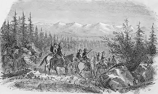
Before going out, however, the miners proceeded to organize a "city." A beautiful site was chosen in the valley of French Creek, a commission appointed, streets laid out and named, lots surveyed and numbered, and all else having been done, a difficulty arose about choosing a name. The miners were about equally divided between Northern men and those from the South. The Northerners wished to call the town "Custer City," and the Southern men wished it to be "Stonewall." Debate ran high, words nearly led to blows, weapons and revolvers were freely brandished; finally a vote was taken, and when the judges of election arose, after counting the ballots, they pronounced the name "Custer City."
The ownership of town lots was decided by each man drawing from a box a folded ticket, on which was written the number of the lot of which he was to become the owner. This town organization took place August l0th, 1875. Two other towns were laid out during the same summer one on Spring Creek and the other on Rapid. But neither arrived at the dignity of a house. Custer City, however, boasted of two large log structures, one intended for a courthouse and the other a hotel. These constituted the towns of the Black Hills, when General Crook brought the miners out in 1875. Early in 1876 Custer became a "booming" gold rush camp. Its streets became crowded with business houses, tents, log huts, dance-houses and hotels; but the placer mines not proving very rich, the population scattered over the country, and upon the discovery of the richer deposits of Deadwood Gulch, later in the season, Deadwood City sprang into life, and became the objective point of the great immigration that was pouring into the Black Hills, and Custer City became almost deserted.
First Discovery of
Quartz Lodes.
During the summer of 1876, the population of the Hills was swelled to a
number not less than seven thousand, most of whom settled in and around
Deadwood City. Other towns were formed, and "Gayville," a mile and a half
above Deadwood, and " Crook City" (after General Crook), eight miles below
on Whitewood Creek, were laid out simultaneously. " Hill City," on Spring
Creek, and "Rapid City," on Rapid Creek, were formed a little earlier than
Deadwood. Central City, two miles up Deadwood Creek, and Lead City, four
miles up Whitewood Creek, which streams unite at the city of Deadwood, were
built about a year later, and became towns of considerable importance,
because lying in the vicinity of some of the great
gold mines of the Hills, at which there was subsequently
large quartz-mills erected.
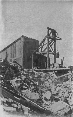
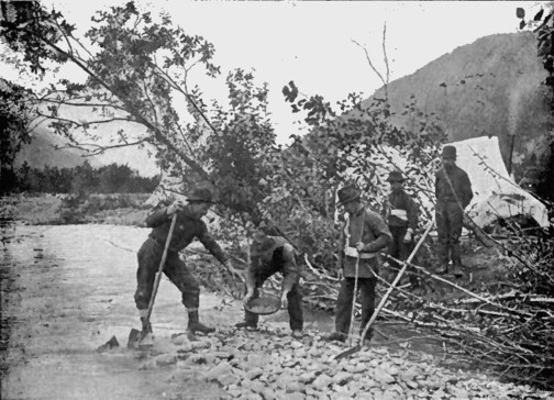
It was an auspicious day for the Black Hills when a miner happened to uncover a ledge of singular-looking iron-stained quartz down on the bed-rock of his gulch claim, near the present site of Deadwood. The gold quartz specimen fairly sparkled with golden grains. He ground it to powder on the flat surface of a large stone, washed it in a prospecting pan, and found it to contain gold at the rate of nearly one dollar for every pound of rock, Druggists' mortars were then brought into requisition, and miners began to pound out from these claims considerable amounts of gold. Quartz locations then became in order, and developments proved the existence of immense deposits of gold bearing quartz in veins of such great size as were heretofore unknown, and quartz mining and prospecting was begun, and has been very actively prosecuted since. This was the spring of 1877.
California capitalists were not long in learning of the great size of these deposits, together with their richness and free-milling qualities, and the ease and moderate expense with which the ores could be manipulated, and in the winter of 1 877-78, they made heavy investments of capital in quartz lodes in the vicinity, and made preparations for the erection of large quartz-mills for the reduction of the ores. These capitalists paid four hundred thousand dollars for the "Father Desmet" mine; eighty thousand dollars for the "Golden Terra;" for the "Homestake," No. 1, seventy thousand; " Homestake," No. 2, fifty thousand, and for the "Old Abe," two hundred and fifty thousand. These mines have since erected mammoth mills. The Homestake built a mill of eighty stamps, following it by the erection of another of one hundred and twenty stamps, being, it is said, the largest quartz stamp mill in the world. The other large companies have erected mills nearly or quite as large, so that the present annual production of gold from quartz alone in the Black Hills has reached the immense sum of about five million dollars.
The gold yield of 1877 was estimated at two million five hundred thousand dollars ; that of 1878, three million five hundred thousand dollars, and that of 1879, at nearly six million dollars. Undoubtedly, however, these figures are large, and probably overestimate the amounts produced rather than undervalue them. However, the production of 1880 fully reached a rate of six millions for all the Black Hills mines. Already we were getting within the exciting influences of the great gold and silver regions of the Rocky Mountains. Here we encountered a party bound for the Black Hills young men, enthusiastic over the prospects of digging gold in the golden Hills. It seems appropriate before entering upon the history of the great gold and silver regions of Colorado and the Black Hills, to say something of the routes of travel by which they can be reached. To the Black Hills: 1st. The northern route via St. Paul and the Northern Pacific Railway to Bismark, Dakota; thence by stage about 245 miles to Deadwood City. This may be a good route in summer, but is open to objections because not open all the year. During the past winter there were weeks at a time in which it was blockaded with snow.
The Black Hills proper embraces ail that country lying between the " North Cheyenne,"or "Bellefourche" River, on the north, the Cheyenne River on the south, and Wyoming Territory on the west. These two rivers running eastward unite and form the Big Cheyenne, making, with the Wyoming Territory line, an irregular triangle containing between five and six thousand square miles of territory, out of which three counties of Dakota have been formed. The western or end lines of these counties lie next to Wyoming, and their longest or side lines run due east and west, Custer County on the south, of which Custer City will be the county seat, Pennington County lying north of it, of which Rapid City is the capital, and Lawrence County the farthest north, lying next to, and bounded by the Bellefourche River on the north, of which Deadwood is the county seat. These are the local subdivisions of the Black Hills country. Harney's Peak, in Custer County, attains an elevation of seven thousand four hundred feet. Terry's Peak and Crow, in Lawrence County, reach a height of seven thousand two hundred feet and six thousand two hundred feet respectively, and are noted peaks. Bald Mountain, a little south west of Deadwood and Bear Butte Peak, about fourteen miles north-east of the same, are prominent land marks. This series of mountains, which occupy an extent of country about ninety miles long by sixty wide running north-west and south-east through the counties named, have a central or granitic portion within the limestone belt which surrounds them at their outer " mesa" of about seventy miles long by thirty to forty wide, irregular in shape but within which all the gold and silver deposits are found.
Return
to The South Dakota Page:
South Dakota Gold Rush History