This state in Australia contains a remarkable series of buried channels, called "deep leads." The gold occurs in gravels of Tertiary streams, which, following a depression, became covered by thick beds of sand and clay, and these in turn by basalt flows of several hundred feet thickness. The gold was first discovered in the upper part of the former stream courses and then followed down under the basalt. Notwithstanding the further exhaustion of the auriferous deposits of the older gold-fields, the estimated yield of natural gold from alluvial mines shows an increase upon that of the preceding year. This increase is supposed to be due to the opening up of new gold-producing areas, in which the rich deposits have been hitherto hidden beneath deep flows of volcanic rocks. The discoveries in these tracts have been greatly facilitated by the operations of the diamond drills imported and worked by the Government; the rapid borings through dense basalt by these machines, and the information disclosed by the cores of rock obtained, have given a great impetus to alluvial mining, and have enabled mining companies to determine the downward courses of auriferous leads at distant points, and to sink shafts with precision either upon or in close proximity thereto. Victoria in the early days was gold rushed by a gold-seeking population who had very little experience in searching for alluvial, and none when it came to extracting small particles of gold from hard rock. Reef after reef was left in the early days because the material was looked upon as too difficult to work; the evolution of quartz mining was slow, the work proceeded cautiously, and even now, owing to this original policy, any change of machinery or method is viewed with the greatest suspicion.
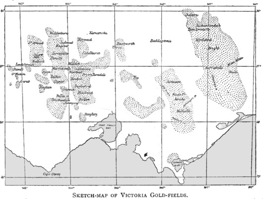
The Seven Chief Gold mining districts of Victoria:
Beechworth district:
The alluvial
gold worked in the Beechworth
district has been derived from the Silurian strata, and not from the
granites. The area of Murray Tertiaries, in which the Ovens and Murray
rivers flow and ultimately join, and into which the deep leads have been
traced, was probably once a hill country, sculptured by streams in highly
inclined strata of Silurian age. Including the whole of the area embraced
within the Silurian hills bounding the confluence of the Ovens and Murray
rivers, there cannot be less than 500 sq. miles of country which has thus
been subject to denudation and erosion, and in which as yet no gold-workings
have been sought for it
Castlemaine district:
In July of 1851 gold was found in here at Specimen Valley. The
mining settlement employed about 30,000 miners
and was called alternatively Forest Creek and Mount Alexander. Captain
William Wright, the chief goldfields commissioner, later named the
settlement for his uncle, Viscount Castlemaine. Castlemaine
is locatedat the south east end of the golden triangle.
Rich and extensive alluvial gravels yielded about 4.5 million ounces
of nuggets. By the 1880s the
gold deposits were mostly
depleted. The Bendigo and Castlemaine goldfields are classic examples of
structurally controlled orogenic gold deposits in the Bendigo Zone of
central Victoria, SE Australia. Detailed mapping and stratigraphic
interpretation has led to a better understanding of the regional structural
controls of this type of gold-quartz mineralization. Mineralized quartz
veins are hosted by the Castlemaine Group, an Early-to-Middle Ordovician
turbidite succession at least 3,000 m thick. Gold deposits are controlled by
low-displacement faults that are clustered into several belts (the
goldfields) indicating a regional structural control. The timing of
mineralization overlapped with that of the major period of deformation
including folding, cleavage development and regional faulting. The Bendigo
and Castlemaine goldfields are located in an area termed the Whitelaw thrust
sheet bounded by two unmineralized, high-displacement, regional-scale
faults. Mapping has revealed an interrelationship between the regional-scale
faults, regional structural style and goldfield location. The goldfields lie
immediately west of the boundary between the upper and lower portions of the
thrust sheet and are characterized by symmetric folds with sub-horizontal to
synclinal enveloping surfaces, relatively low co-axial strains and moderate
cleavage development. The non-gold-bearing
areas immediately east of each goldfield correspond with the lower part of
the Whitelaw thrust sheet and are characterized by higher non-coaxial
strains, stronger cleavage and folds with wide west-dipping limbs giving
rise to easterly divergent sections and steeply west-dipping enveloping
surfaces. That mineralization was an integral part of the thin-skinned style
of deformation in the central Bendigo Zone is indicated by timing
relationships and the interrelationship between local-scale mineralized
structures and regional-scale features such as large-displacement
unmineralized faults, regional variations in fold style and overall thrust
sheet geometry. The work supports previous models that suggest mineralized
fluids were focused along a linked system of deep-seated faults. The primary
conduits may have been major regional-scale ‘intrazone’ faults, which are
inferred to sole into detachments near the base of the Castlemaine Group.
The distribution of gold deposits and of gold production suggests that
maximum fluid flow was concentrated along the eastern margins of networks of
low-displacement faults.
Gippsland district:
The alluvions in much of Gippsland consist of shallow workings in old
gravels on hills, as at Kaffir's and New Zealand hills at Foster; river,
creek, gully, and high bank or terrace workings, where the deposits are the
result of recent geological action, and the gold has been either derived
from immediate erosion of local matrices during such action, or from the
denudation and re-distribution of more ancient drifts ; lead workings in
gravels referable to the Miocene and Pliocene drift periods, of which some
are above and some below the level of existing drainage channels. The
principal river-workings are in the Tarween and Tangil rivers, in both of
which the richest deposits of
gold were found below where
old gravels had been denuded, as at the mouth of Langridge's Gully, on the
Tarween, and immediately below the tunnel cement workings on the Tangil.
There are numerous other workings" of greater or less extent and richness
throughout the district, as Crossover, Deadhorse, and Livehorse gullies,
Russell's Creek, Turton's Creek, and others of less note.
Maryborough district:
The first big
gold rush
commenced in June 1854, at Four Mile Flat and as word reached other areas
the rush turned into a tidal wave of diggers moving into the area. In just
one month the population swelled from 150 to over 1000, and two months later
that number had swelled to an estimated 7,000. In another two weeks the
human tide had reached 20,000 plus souls, and by the middle of September it
had reached 27,000. Allong with the gold rush miners came the usual
storekeepers, brothels, sly grog shops (illegal liquor) and hotels, who set
up tents along the road, at times the proprietors fighting for the most
advantageous locations. By the end of 1854, the population was estimated at
close to 60,000. Gold was literally oozing from the ground from new finds in
the area. Most
gold
was found within a radius of about 10 miles from Maryborough itself. One of
the gold bearing areas was called Waterloo, after a reputed battle between
the Irish and the English miners, was fought as a bare-knuckle engagement
there. There was no doubt who won the day. Another pitched battle occurred
between Chinese factions just south of Maryborough in August 1855. It was
indeed a frontier town. During the height of the gold rush, this area
produced about 8,000 oz. of gold a week that was taken under escort to
Melbourne. The sheer volume of gold that the ground gave up was staggering,
and stories of good and bad luck abound. One disgruntled digger walking away
from the mines found a 73 oz. gold nugget on the side of the road. A digger
abandoned his claim only to have another take over 430 oz. from it in total,
with
gold nuggets
up to 63 oz. Two Prussians unearthed a nugget weighing 492 ounces, at a
depth of 7 feet in August 1854.
The main lead extended for over 8 miles, with a large portion of the recoverable gold near the surface. It was easy pickings for experienced diggers, many of whom had come from Ballarat , Bendigo, and from Avoca. Gold was so plentiful that even doctor's, lawyers and the like shed their suits and joined the diggers. A group of Americans washed 80 oz. of gold from one bucket of dirt, and many small claims produced over 800 oz. of gold. One claim recovered on average 16 oz. of gold per shovel full of dirt at its base. It appears that the town of Maryborough was central to most of the rushes, with diggers upping stakes and moving from one rush to the next as they occurred, at times on a weekly basis. One old timer described these movements as "A shifting sea of humanity". The stability required to establish permanent buildings was not evident until early in 1855, when brick and timber buildings began to be erected along Main Street. Yet buildings were built and by the time Mark Twain arrived, he described Maryborough as a "railway station with a town attached".Gold was being recovered in ever increasing volumes, with large nuggets being the order of the day. In two months 3 miners wrought 1,000 oz. from near Oppossum Gully. Some areas produced 60 oz. to the ton. But on average 5 oz to the ton was the norm. At least 44 different reefs had been discovered and were worked at Maryborough. At the Main Lead the owners of one claim recovered 497 oz. from one load of wash dirt. Stories of such wealth abound from this fantastically rich area. In 1857 the total escort figures of gold from one small area was 35,409 oz of gold. This figures excludes what was sold or removed privately from the diggings.
The Scandinavian rush, south of Maryborough in 1858, gave incredible riches. 300 oz, from 4 buckets of wash. 70 oz. from just one bucket, and 327 oz. in another bucket. These are the recorded finds, but unrecorded finds reveal that what was officially recorded was but a small fraction of what was got from this rich ground. At about the same time a rush near Emu, 5 miles from Maryborough reaped great wealth for the 10,000 who flocked there. This rush and the inhabitants at Emu became known more their debauchery, orgies, drunkenness, fights, gambling, vice and cruelty. Local entertainment included rival whores fighting in the street bare to the waist in roped off areas. Murder and mayhem were rife and very few murderers were brought to justice in this place. During the Coxtown rush one small claim produced almost 10,000 oz. of gold. It was common place to return up to 100 oz. of gold to the load. A short time later another rush occurred to Chinamans north of Maryborough and fabulous weights of gold were recovered to the load. About 15,000 joined this rush. Total gold escorts in 1857 from this area were 146,412 oz. of gold.
Late in 1857 a rush occurred at Havelock north of Maryborough, which attracted about 10,000 souls. Good gold was got here with about 16 oz. to the load of wash dirt. Crime was again rife, and on one night a storekeeper named Lopez woke to find a dark figure robbing his store. When challenged the robber, Joseph Banks shot Lopez in the chest. The mortally wounded man was able to inflict serious knife wounds on his assailant, who later died. Banks had been part of a gang camped nearby and when the officer in charge of the local police station, Edward Barnett, went to arrest the other gang members he was shot dead. The local diggers took matters into their own hands, and at dawn surrounded the gang and captured the man who had shot Barnett, and burnt the sly grog shops and brothels nearby. By mid afternoon the other gang members had dispersed and calm returned. By 1864, the majority of gold in and around Maryborough had been claimed. The area had been incredibly rich and had provided great fortunes for many. Perhaps the less savory side of life in the Maryborough goldfields was not unlike that of other fields. Perhaps the recording of such happenings was in greater detail than other places. It was an exciting place at the time. A time of great promise. A chapter in the history of Australian gold that provides an outstanding insight into the life and times of those pioneers who ventured forth to find their fortunes.
Sandhurst (Bendigo) district:
The most N. and most important gold-workings are at and in the vicinity
of Rushworth, where, at the close of the September quarter of l877, there
were 563 alluvial miners were employed in mining. The principal alluvial
workings are, or have been, on the Old lead. The head of the lead is in
Growler's Gully, at the back and to the W. of the township. This lead trends
E., and probably terminates in the Waranga Swamp. Many rich tributaries flow
into it, but those joining it on the S. side are the most considerable. This
lead has yielded more gold than any other in the district ; it is but
shallow, as the deepest shafts sunk on it are only 35 to 55 ft. in depth.
The character of the cement and wash-dirt in the lead is very like the Deep
lead at Bendigo, and both are probably of the same age (Older Pliocene :
oldest gold-drift). More information on Bendigo can be found here:
The
Bendigo Goldfield Of Victoria
Ballarat district:
In Ballarat, Australia, the “wash-dirt '' runs in a series of "leads" of
varying width, starting from the same point, and trending in different
directions towards the "deep leads." The "reef wash" is about 100 feet deep,
the "pay dirt" 5 feet. The barren drift wash overlying the "pay dirt" is of
black clay. The reef itself is of green slate, the bed-rock is sandstone.
Gold lies sometimes on thin layers of sand or "pipe clay" on the surface of
the "bed-rock," more often in crevices of the bed-rock itself, which is more
or less rotten. This bed-rock is broken up for some 12 to 20 inches and the
gold is found in "pot-holes"
in it 15 to 18 inches in diameter and 6 to 10 inches deep, cut out of the
solid rock. The alluvial gold is found chiefly in bed-rock of slate, dip
ping 90 degrees. Some of these slates are soft and rotten, while others are
indurated. On the soft rock only is the gold found. Nuggets are found in the
soft clay lying on “bedrock." Slate forms natural "riffles" for catching the
gold. Deep pools under waterfalls in gold-bearing streams rarely carry much
gold. So in rivers, gold is found in “bars" or points rather than in deep
pools or bends.
Gold-workings. The surface workings are usually on the slopes of hills and spurs ; the gold is sometimes in the few inches of surface soil and angular rubble overlying the Silurian on or near auriferous quartz veins, as at the Black Hill, Whitehorse Hill, &c. In other places, a few scattered rounded quartz pebbles show that "oldest" or "older" drift once rested on the Silurian, and was removed by denudation, the accompanying gold, from its superior weight, remaining in the crevices of the bed-rock. Surfacing is sometimes worked on a "false bottom" of clay covering deeper deposits of auriferous drift ; this also occurs most frequently in close proximity to quartz veins. At Kitty's, near Napoleon, tolerably large nuggets have been found in clay several feet above the " true bottom." The thicker deposits at the foot of the hills and in the gullies intersected by auriferous lines of reef are frequently gold-bearing from surface to bottom, owing to the proximity of the matrix. It is stated that at Rotten Gully, near the Band of Hope reef, Little Bendigo, where the sinking is about 70 ft, 40 ft. was payable.
Ararat district:
A marked feature, at once noticed by a visitor from the central
gold-fields, is the absence of shallow alluvial "ground" in this district.
The depth of the Flint Hill drift is from 20 to 40 ft., and contains
gold distributed throughout
the whole thickness. The coarse "shotty" gold is usually, but not
invariably, on the bottom or bed-rock. The total quantity of gold raised in
Victoria from the period of its first discovery in 1851 to the end of 1880
is given by two official statements respectively as follows: a. 49,549,051
oz.; and b. 49,646,717 oz., On a large scale similar conditions prevailed in
Victoria, Australia. Here there existed in Pliocene time an extensive river
system with shallow, well washed, and locally extremely rich gravels which
were formed during a prolonged time of nice balance between erosion and
deposition. The region then became depressed and covered by thick beds of
sand and clay. Above this were poured out basalt flows, in places several
hundred feet thick (Figs. 79 and 80). The broad valleys remain on the whole
as before, but the present streams are weak and have little power of
transportation and concentration. The discoveries of gold were made near the
sources of the old rivers, where their gravels are near the surface; they
were followed upward into the gullies of the slate hills, and downward below
the level of the basalt flows. Such were the conditions, for instance, at
Ballarat. South of Ballarat certain of the Pliocene stream gravels merge
into coastal gravel plains, soon becoming marine in character. Such coastal
gravel beds are opened in the Pitsfield mines, where the pay streaks of fine
gold, resting on an almost level bed-rock, are worked beneath several
hundred feet of sands and gravels.
The depressed gravels of earlier periods are worked by drifting from shafts, as in Victoria, where, however, the preliminary pumping, to permit access, is an extremely heavy expense, often indeed prohibitory. Some of these Australian channels have been extremely rich, the workable portions ranging from $2 to $15 per cubic yard. Some of the channels are in places several hundred feet in width. The richest drift mine worked was probably "Madame Berry" in Victoria, with average width of 450 feet, yielding $1,293 per foot along channel. The two claims below this produced, respectively, $843 and $443 per foot, the last named channel being mined 1,000 feet wide.
Continue on to:
The Bendigo Goldfield Of Victoria
Return To:
Important Gold Mining Regions Worldwide