Among the names which won a world-wide fame during the golden age of the early fifties, Bendigo and Ballarat were to Australia, what the Yuba and Grass Valley were to California. The map of Victoria did not for a long time show the name of old Bendigo; for this first and more distinctive name was replaced with the more English Sandhurst, just as the alluvial diggings gave place to quartz mining. Towards the close of last year, steps were taken to give back the old name, as associated with the early days of rich alluvium, and more suggestive than the application taken secondhand from an English military academy.
HISTORY:
The first discovery of
gold in this district, was
made in the autumn of 1851 ; but there has never been any certainty as to
the day or the man. At that time the country around Bendigo Creek was a part
of the Ravenswood sheep-run, and its resemblance to the Forest Creek
district (now Castlemaine), induced the first prospecting. It was late in
November when the "rush" broke out; the shepherds left their flocks ; the
sylvan solitudes were disturbed by the voices of the first "diggers ;" the
green glades of Bendigo Creek were ruthlessly uptorn by pick and spade ; and
the busy energetic life of a young and thriving mining camp replaced the
sleepy idle routine of an out-of-the way sheep-station.
Since that date the gold-field has yielded over fifteen million ounces of the precious metal, valued at more than sixty millions sterling. Like most mining districts, it has passed through days of severe depression and extreme inflation. Until 1854, the alluvium only was worked. The pan and the cradle early gave way to the paddling-tub, a machine more suited to the clayey character of the wash. By reason of the limited supply of water, the long torn was never very widely used. The highest output on record was reached in 1853, when 661,729 ounces, valued at 2,646,800, were obtained from the alluvium only. Long before the diggers were aware of the real value of gold-quartz, they used to amuse themselves by breaking off specimens from the outcrops for decorative purposes. Diamond Hill owes its name to the beautiful specimens which its surface yielded in the* early days. Vein-mining or "quartz-reefing" had its inception with the discoveries made by Ballestedt on Victoria Hill, which has now been pierced for a depth of over half a mile, and is honeycombed with deep workings. From 1854 to 1862, the quartz-mining industry had a chequered career; as will be readily understood when the peculiar character of the ore-deposits has been passed in review. In 1859 the first regular registration of a quartz mine took place. About this period the shallow alluvial deposits became exhausted and, in the absence of deeper channels, the whole energy of a very enterprising community was concentrated upon the exploitation of the quartz-lodes. In 1862 the first limited-liability company was brought out; and in the immediately succeeding years the steady development of the field and the increasing knowledge of the lode-structure were accompanied by an increasing gold-output, which rose in 1870 to 241,380 ounces. The formation of numerous companies which marked the early seventies, introduced fresh capital into the district, and thus led to great increase in the work done in the mines, the output from which averaged at this time over 300,000 ounces per annum. But company-promotion soon developed into a mania which rapidly did its evil work.
Paper mining replaced honest work, as it has done in many another mining district before and since. A reaction set in ; the gold-field saw its darkest days; and a collapse took place which ended the wild speculation in bogus companies and marked the commencement of a new era of steady progress. The opening up of deeper ground and a renewal of rich discoveries, brought about a revival in the first years of the last decade, which, accompanied as it has been by great enterprise, and the intelligent development of the mines with a more accurate knowledge of their ore-deposits, has enabled the Bendigo goldfield to hold the first place among the quartz-mining districts of Australasia, and to make its record unique in the statistics of this industry. less known, considering their importance, than those of the colony of Victoria. The steamship, the railway, and the telegraph, have linked together the most distant mining centers, Broken Hill and Virginia City, Johannesburg and Grass Valley; but the older goldfields of Australia have received but a superficial and passing notice from the pens of standard writers. More particularly is this true of Sandhurst or Bendigo, which shares with Ballarat the first rank among the Australian localities of quartz-mining. This mining center and its peculiar ore-deposits it is my purpose to describe, from the notes of a recent examination. The time three mouths was insufficient to enable me to give to the field the extended study which it invited; and I would leave the subject to better hands, did I not believe that the objects of our Institute are best carried out, when its members place on record the different facts observed in different countries, in order that a mass of observations may ultimately be accumulated, which those best qualified may combine and discuss.
GENERAL DESCRIPTION:
At the outset a general description of the appearance of the goldfield may
be of interest. A very good view can be obtained from the upper platform of
the Old Chum poppet-heads, on Victoria hill. The air is usually clear, and
from this point of vantage one can see a long way. The district lies among a
series of undulations which rise above the tame level of the surrounding
plains. The even line of the latter is further broken by several hills,
marking the granite bosses which penetrate the overlying slates and
sandstones. To the north, poppet-heads and tall red brick chimneys in long
succession indicate the various great lodes or " lines of reef," stretching
out to Eaglehawk, four miles away, while out in the distance be- yond is the
dark blue sea of the trackless bush,* broken in front by the hills at Kerang
and to the right by the promontory of the White hills, a name familiar to
every Australian digger. White hills they are no longer, for the "cement"
which covered the rich alluvium has become oxidized, and patches of red
gravel-heaps have replaced what was once glistening white. Between these and
the spectator lies the modern city of Sandhurst, its well laid out streets
lined with the English trees which have replaced the gums that once covered
the site. A wavering, blue, irregular line marks Bendigo creek, once flowing
through the forest glades, but now meandering past tailing-heaps and back
yards. Out beyond the town we can dimly see Mt. Ida, where Heathcote lies.
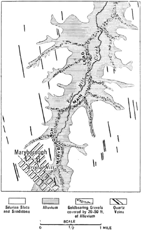
Southward the succession of poppet-heads marks the auriferous belt. The engine houses of the South Bellevue and Eureka Extended mines indicate the New Chum reef, on which there is operated to-day perhaps the greatest series of deep gold-quartz mines which the world has yet seen. A new church rises above Golden Square, the scene of some of the first and richest of the alluvial diggings. The view is further diversified by gray heaps of tailings, bluish piles of waste rock, gar- dens and houses, among which is seen the sinuous curve of the railway along which the Melbourne express is now coming. Further south, in the distance, are the granitic slopes of Mt. Alexander, beyond which lies Castlemaine. To the west, clouds of sulfurous smoke indicate the various pyrite -works, and a black line against the blue sky marks the water supply flume, while immediately below us are the gardens and house of one of the mine-owners, an oasis of pleasant green among the stern practical surroundings of mines and mills. Sandhurst or Bendigo has a population of over 30,000 inhabitants, several fine public buildings, and some very beautiful public gardens. It is connected with Melbourne, the chief port and metropolis of Victoria, by a double-track railway 101 miles long, constructed at a cost of 18,000 per mile. Victoria is divided into seven mining districts, of which the most important are Ballarat and Bendigo, the former being the chief alluvial center, while the latter leads the quartz-mining districts. The total area of the Victoria gold-fields, 86,760 square miles, is worked and prospected by a force of 23,833 miners ; and the proportion belonging to the two principal gold-fields is as follows: The deposits of the Bendigo district are practically concentrated upon an area of 21 square miles within the adjacent townships of Eaglehawk and Sandhurst.
During the past 2 years the yield of gold has been: It is seen that, while Ballarat is the leading alluvial district, it produces also a large proportion of natural gold from quartz, while at Bendigo, on the other hand, the alluvium is relatively important. The figures just given bear out the statement of the Secretary for Mines that the diminution of the gold-yield is chiefly in that from the alluvial mines. In both the leading centers the yield from quartz has slightly increased, while that from alluvium has considerably diminished. The average yield of the quartz per ton of ore crushed, during the past year, was as follows Bendigo, 3 17s. and 3 19s., and at Ballarat, 3 17s. 6d. and 4 3s. While in the early days of the colony as a whole, the number of miners were pretty equally distributed between alluvial and quartz mines 11,470 in the former to 12,363 in the latter there is, in the two leading districts, a greater disproportion ; Bendigo having 949 alluvial and 3375 quartz-miners, while Ballarat has 2440 alluvial and 3677 quartz-miners. At Sandhurst there are 270 Chinamen, nearly all engaged in surface-washing, while at Ballarat there are 736 Mongolians to 5508 Europeans. The country of the Ballarat gold-field consists of the Lower Silurian slates and sandstones, which also enclose the reefs of Bendigo; but it is noteworthy that the successive anticlinal folds, and accompanying saddles of quartz, which distinguish Bendigo are not characteristic of Ballarat, the geological structure of which presents greater complexity. That part of the district known as Ballarat East became famous early in its history on account of the large nuggets which were found in the alluvium, and subsequently it became further known because of a peculiar persistent black seam, traversing the bed-rock underlying the alluvial deposits, which was found to be associated with rich bunches of gold ore, not only in the gravel that capped it at the surface but also in the quartz-veins which crossed it underground. The name of " Indicator" was early given.
. In 1871 Mr. Morgan Llewellyn directed attention to it as influencing the distribution of the gold. In the government quarterly report for December, 1888, Mr. E. J. Dunn described a similar occurrence observed by him in the neighboring district of Wedderburn. In September, 1893, the writer contributed a note on the subject, f Mr. Ernest Lidgey, of the Geological Survey of Victoria, made a special report on the Ballarat East gold-field, which was published in 1894. In 1895 and again in 1897 Mr. "William Bradford added further data.
Mr. Bradford, who lives at Ballarat and has made a careful study of the district, describes the Indicator as " a pyritic sheet, varying in width from one-eighth of an inch to about an inch, which has been formed in an almost parallel line with the " Flat make of quartz displaced by a slide break. Nuggety gold was met with at the point where the Indicator intersected the quartz on the higher side of the break. Down the line of the break a layer of gold in the form of fine particles was found, and traced to the point where the lower part of the quartz occurrence abutted on the break."
Mr. Dunn, the distinguished geologist, whose work on the neighboring gold-field of Bendigo is well known to the members of this Institute, describes the Indicator at Wedderburn as being a " bed of rock of dark-grey to black color, and from 5 to 7 inches wide, made up of thinly laminated unctuous clay." Mr. Lidgey, in his special report, says: "These indicators are usually thin beds of dark-colored shales and slates, formed of a carbonaceous mud, containing a large percentage of iron sulphide. They are parallel, and, so far as worked, nearly vertical, any change from the vertical being usually due to the presence of faults." The most persistent of the series, known as " The Indicator," he describes as " a narrow bed of dark slate, usually showing cleavage planes, and containing a large percentage of pyrite, distributed irregularly through it."
Continue on to:
The Alluvial Deposits of Western Australia, Part I
Return To:
Important Gold Mining Regions Worldwide