I. GENERAL GEOLOGICAL
CONSIDERATIONS:
The interior of West Australia is an arid table-land, elevated 1400 feet
above the sea. This plateau is flanked to the south by the Tertiary
limestones which fringe the Great Australian Bight. It is bordered northward
by the Carboniferous beds of the Fitzroy river and westward by the granite
of the Darling hills, while to the east this wide area, about 900 miles
square, slopes downward imperceptibly into an undulating plain of sand,
which stretches with dismal persistence across the boundary of South
Australia. The waters of the ocean receded from this tract of land long ago
; it is probably the oldest land surface on the globe, and represents the
basal wreck of a much larger continent. The average mean maximum day
temperature for January is very nearly 100 degrees for the Coolgardie
goldfields. while the Murchison is 105 degrees. The nights are said to be
cool, but this is only relative to the day temperature. There is no doubt
that a continual sun bath from early in the morning until late in the
afternoon is not conducive to the comfort of most people. The winter climate
is said to be delightful. It cannot be said that flies or mosquitoes are
troublesome: possibly with the advent of water they will multiply and
increase.
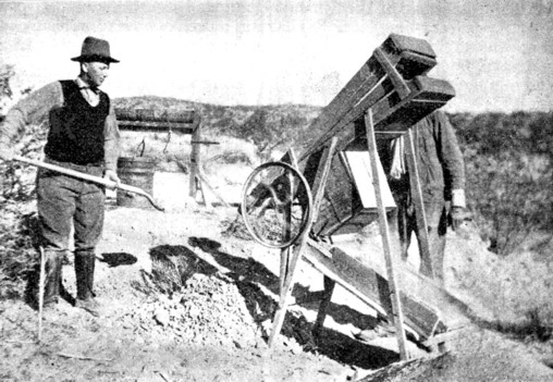
One of the most noticeable features at Kalgoorlie is the enormous plants that are operated on such small areas; coincident with this is the hurry and bustle that goes on. Many of the mines contain little or no free natural gold; in others veinlets of telluride of gold, or blotches of the same mineral, barely distinguishable from pyrite, permeate the rock. The matrix which contained the gold was not quartz, neither were the lodes, so-called, contained in a channel with defined walls. The Coolgardie and Kalgoorlie gold-fields are situated in the southwestern part of the region. The rock-formation consists of granite penetrated by diorites and andesites. The latter are occasionally associated with tuffs, which have been readily mistaken for sedimentaries. There are no fossil-bearing rocks, such as would afford a datum-line from which to measure the relative geological age of the prevailing formation. On the extreme edges of the mining territory there are, it is true, remnants of sand-rock which are considered identical with the " Desert Sandstone " of Queensland, determined by Daintree to be of Mesozoic age. But even this formation has evidently been laid down so long subsequent to the underlying rocks that it serves merely to emphasize their much greater antiquity.
In their characteristics and in their relations to each other, the granite and the diorite of the Coolgardie region appear to me much to resemble the Laurentian granite and the Huronian schists of Ontario, in Canada. Their age can only be vaguely described as Archaean. On many parts of the earth's surface a long-continued, slow movement of continental uplift, interrupted by intermittent periods of rest or subsidence, has permitted the transfer of land to the sea by the erosion of the exposed parts and the deposition of their detritus as ocean sediment, thus causing the up building of a mountain-system composed of a series of rocks belonging to successive epochs. In this particular region, on the contrary, all diversity is wanting, and a sameness of aspect wearies the observer. In the absence of an elevating movement, more than sufficient to balance the slow degradation of the higher parts of the region, there has been no compensation for the effects of atmospheric erosion, so that this tract has become a dreary flat, strewn with the sandy wreck of weathered rocks. The United States offers both a contrast and a parallel. In the Rocky Mountain region the movement of uplift which commenced in pre-Cambrian times has only been interrupted so as to permit of the laying-down of younger sediments; and the degradation of the high places has been compensated, and sometimes exceeded, by an elevation which has resulted in the formation of a mountain mass flanked by a long succession of strata now enclosing a great variety of mineral wealth. The interior of Australia can be likened to the Great Basin, occupied by Nevada and parts of Utah, Idaho and Arizona, between the Rocky Mountains themselves and the Sierra Nevada.
There is only one large river in Australia which reaches the sea, namely, the Murray, which rises near the boundary-line of Victoria and New South Wales, and then flows toward the interior, to be saved by a backward sweeping curve, which permits the river at length to empty itself into the sea at the border of South Australia. There are many "lost rivers," like the Carson and the Humboldt in Nevada. During the rainy season they are tempestuous torrents; during the succeeding dry months their course is marked by sandy bottoms, dotted with an occasional water-hole. The mountains are near the coast, so that the Australian Alps and the Blue Mountains do the same service as the Sierra Nevada and the Cascades, in that they interrupt the warm, moisture-laden winds, and compel them to precipitate on the seaward slope. The consequence is that the eastern parts of the colonies of Queensland, New South Wales and Victoria, between the mountains and the sea, resemble the valleys of California and Oregon, just as the interior region beyond them bears a likeness to the dry tracts of Nevada and Arizona.
The sea retired from the interior of West Australia in the very dawn of geological time, and the movement of elevation, which raised the land above the waters, continued with but little interruption until the beginning of the Tertiary period. Since then, slow subsidence has robbed the Australian continent of a part of its extent, and made Tasmania an island. There is evidence of a much larger continental area, which at one time extended toward Southern Africa. The encroachment of the sea has crowded a wonderful variety of flora into the small stretch of fertile country lying between the desert and the Indian Ocean. The main drainage of the interior is to the south. The last retreat of the sea was accompanied by the formation of broad valleys, which have lost their former outlines, and now appear as long depressions, largely filled up with the products of erosion.
Continue on to:
The Alluvial Deposits of Western Australia, Part II
Return To:
Important Gold Mining Regions Worldwide