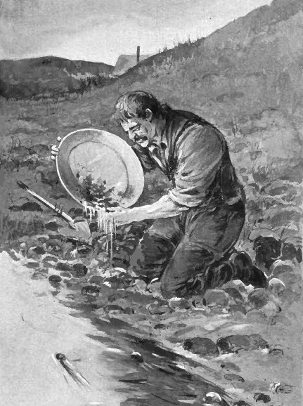
The discovery of auriferous gravels in the Sierra range of California was the beginning of the new epoch. This find was made by James Wilson Marshall, a partner in the mill, who on January 19th, 1848 observed in the debris washed down by the tail-race a glittering fragment of a mineral unknown to him. Suspecting it to be gold, he sought for further specimens, and obtained, in the course of a few days, several ounces of it. Tests subsequently made established its character; and the news spread with great rapidity, arousing intense excitement throughout America, and even in European countries. On March 15th, 1848, a San Francisco newspaper contained a paragraph giving the tidings. In May, the same paper announced the suspension of publication; and the editors and workmen, imitating their fellow-citizens of every class, went off to the diggings. Two years later, the population of California had risen from 15,000 to 100,000; and the gold-bearing zone, extending along the west flank of the Sierra to Oregon, had been put under active exploitation. At first gold was easily found, and but little skill was required in separating it from the loose gravel or sand in which it was imbedded. Frequently it lay so near the surface in such quantities and in grains of such form and size, that a simple pan or rocker comprised all the means necessary, with ordinary labor, to insure extraordinary profits. Mere will and muscle were sufficient.
In the early days many men found nuggets of the size of hen's eggs, and a few washed out chunks as large as apples. It was poor diggings where $20 or $25 worth of gold was not panned or rocked out in a day. The best average day's work of a common miner, working alone, yielded about two and a half ounces of natural gold. The shallow portions of the placer diggings along the rivers and streams were shortly exhausted, but for some years, they yielded fantastic amounts of gold – millions of ounces of gold were dug by the 49er prospectors who were first on the scene. The dirt and gravel in the creeks and ravines was a foot to five or six feet in depth, down to the bed work. Afterward, the placers of the deep or high ancient tertiary channel gravels, lying chiefly in Nevada, Placer, and Sierra counties, were then worked on a grand scale for many decades, yielding significant gold. Most of the deep diggings were discovered after the creeks and ravines were worked out. The great placers of the Mother lode region have been derived from the wearing down of the Sierras, and are found in those valleys leading off the drainage from the mountains. Many were formed during the Tertiary period, when the Sierras were subjected to a long-continued denudation, while violent volcanic outbursts at the close of the Tertiary have often covered the gravels and protected them from subsequent erosion. These lava cappings are at times 150 to 200 feet thick, as in Table Mountain, Tuolumne County.
The gravel region proper, or that portion of the western slope of the Sierra Nevada here to be especially described, may be said to be nearly conterminous with the belt of auriferous slates. Where granitic rocks prevail, whether in the southern portion of the Sierra, or along the crest of the range, the gravels are local in character and with only a few exceptions, do not contain significant gold. The true gravel-mining region begins in Mariposa County and extends into Plumas, as far as the line marking the limit beyond which the slope of the Sierra is entirely covered with volcanic material. But all portions are by no means equally important, either in respect to the amount or the richness of their gravel. Taking the counties in geographical order from south to north, the importance of the gravel deposits increases from Tuolumne to Calaveras, and thence to Amador; El Dorado, Placer, Nevada, and Sierra are the great mining counties, and continuing through Butte and Plumas north of which the gold bearing rocks are buried under deep lava blanket. The location of the auriferous gravels themselves shows clearly that their presence is entirely dependent on the existence of a mineralized body of slaty rocks, enclosing great numbers of quartz veins, which in many cases are sufficiently well supplied with gold to repay the expense of mining. In short, the region of the quartz mining districts and the placer gravel region are essentially one and the same tract of country, as is apparent on inspection of the various maps showing the locations of the gold deposits.
The auriferous gravels of California are of two general types: buried placers of Tertiary age and normal stream placers of Quaternary age. The gold was derived from the many gold-bearing Veins, including those of the Mother Lode, in the mountains that had been formed at the close of Jurassic time by the intrusion of the Sierra Nevada granitic batholith, most of which was emplaced in Late Cretaceous time. A long period of erosion followed during Tertiary time when the mountains were nearly leveled, and gold from the eroded parts of the veins was concentrated in stream channels. Some of the resulting Tertiary placers were extremely rich. The Tertiary drainage system consisted of six main streams. One of these, the Jura River, flowed northward in Plumas County; the others flowed westward. The names of the major westward-flowing streams, not to be confused with their present-day counterparts, are the Yuba in Yuba and Nevada Counties, the American in Placer and El Dorado Counties, the Mokelumne in Calaveras and Amador Counties, the Calaveras in Tuolumne and Calaveras Counties, and the Tuolumne in Tuolumne County. Near the end of the Tertiary Period, much of the region was covered with volcanic debris, composed chiefly of andesite. The old drainage pattern was obliterated, but a new one soon developed on the new volcanic surface as the present Sierra Nevada range was uplifted. During Quaternary time the new streams cut deep canyons through the volcanics, exposed and eroded parts of the old Tertiary channels, and reconcentrated some of the gold in the gravels of the new streams. Only the scattered remnants of the Tertiary channels, which are higher than the channels of the present streams, are now found preserved beneath ridges of resistant volcanic rocks. Rich Quaternary placers have been mined very successfully in numerous districts along the present-day Feather, American, Yuba, Mokelumne, and Merced Rivers, and low-grade Quaternary placers have been profitably dredged in the central valley where the gradient of these rivers is nearly level and only fine-grained gold is concentrated.
The bedrock in the Mother Lode counties consists of steeply dipping, northwest-trending belts of phyllite, schist, slate, and greenstone, intruded locally by small bodies of peridotite and granodiorite. The oldest rock unit in the area, the Calaveras Formation of Carboniferous age, is composed chiefly of black phyllite with minor quartzite, limestone, and chert. Green amphibolite schists are interbedded with the Calaveras Formation and are believed to be of equivalent age. Overlying the Calaveras Formation is the Mariposa Slate, of Jurassic age. This unit, which is considerably less metamorphosed than the Calaveras, consists of black clay slates and graywacke with small local bodies of conglomerate, sericite schist, and limestone. Greenstones are intimately interlayered with the black slate. The rocks have been invaded by intrusives of several ages. The Calaveras Formation is cut by metadiorites, and both formations are intruded by lenses of serpentine, which was originally peridotite, and by dikes and masses of hornblendite, gabbro, granodiorite, and albitite porphyry. Potassium-argon age determinations from minerals in some of these granitic bodies give evidence of two separate orogenies in Mesozoic time-one in Late Jurassic and one in Late Cretaceous.
During the early days of gold mining in California the gravels at lower levels and in the valley bottoms were worked, but as these became exhausted, those in the earlier operations the gravels were washed entirely by hand, either with a pan or rocker, and this plan is even now followed by small miners and prospectors; but mining on a larger scale is carried on by one of three methods, viz. drift mining, hydraulic mining, and dredging. Many of the gravel deposits are on lines of former drainage, while others lie in channels still occupied by streams. Some show but one paystreak of gold, while in others there may be several, some of which are on rock benches of the valley bottom. Drift mining is employed in the case of gravel deposits covered by a lava cap, a tunnel being run in to the paying portion of the bed and the auriferous gravel carried out and washed. In hydraulic mining, a stream is directed against the bank of gravel and the whole washed down into a rock ditch lined with tree sections, or into a wooden trough with crosspieces or riffles on the bottom. The gold, being heavy, settles quickly and is caught in the troughs or ditches, while the other materials are carried off and discharged into some neighboring stream. Mercury was sometimes put behind the riffles to aid in catching the gold.
The water which is used to wash down the gravel deposits in hydraulic mining was often brought a long distance, sometimes many miles, and at great expense, bridging valleys, passing through tunnels, and even crossing divides, this being done to obtain a large enough supply as well as a sufficient head of water. Owing to the great amount of debris which was swept down into the lowlands, a protest was raised by the farmers dwelling there, who claimed that their farms were being ruined; and it soon became a question which should survive, the farmer or the miner, for in places the gravels and sand from the washings choked up streams and accumulated to a depth of 70 or 80 feet. The question was settled in 1884 in favor of the farmer by an injunction, issued by the United States Circuit Court, which caused many of the hydraulic mines to suspend operations; and at a later date this was extended by state legislation, adverse to the hydraulic mining industry. Owing to this setback, hydraulic mining fell to a comparatively unimportant place in the gold-producing industry of California, while at the same time quartz mining increased.
The passage of the Caminetti law was passed to permit hydraulic mining, but requires that a dam shall be constructed across the stream to catch the tailings. This resulted in a revival of the industry, but even so, the placer mining industry is seriously hindered by the present laws governing it. Dredging consists in taking the gravel from the river with some form of dredge. The method, which was first practiced in New Zealand, has been introduced with great success into California, especially on the Feather River, near Oroville, and its use has spread to other parts of the Cordilleran region and Alaska. The gravel when taken from the river is discharged onto a screen, which separates the coarse stones, and the finer particles pass over amalgamated plates, tables with riffles, and then over felt. Placer gold is also worked in throughout California, with the bulk of the deposits with a few exceptions are mostly from Mesozoic veins. Gold also occurs in beach sand of certain portions of the Pacific coast in California, and placer mining has been carried there on for many years but the supply of gold from beach operations has always been small. In the arid regions of the state, where the gold-bearing sands are largely the product of disintegration, and water for washing out the metal is wanting, a system known as dry blowing is sometimes resorted to.
Continue on to:
California Gold Deposits, Part 2
Return To:
Important Gold Mining Regions Worldwide