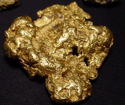
During the year 1848 the gold region of California was explored and worked from Coloma to the Tuolumne in the south, and to Feather River in the north, with a slight inroad upon the country beyond and westward to the Trinity. It might have been expected that observations would have extended farther in the south, since this was in a measure the pathway from Sonora and southern California; but hostile Indians, and the distribution of gold in patches and less regular streaks in dry ground, tended to discourage the casual prospector. In the north, on the other hand, every bar could be counted upon to contain sufficient color for remuneration or guidance, with greater indication of finding in this quarter the supposed mother beds. The inflowing hordes of 1849 and subsequent years followed the paths so far opened, and passed onward to the poorer districts beyond the Merced, and into the more attractive north-west, beyond the borders of Oregon and into Nevada.
The attention of new-comers continued throughout these early years to be directed toward the American River, as the chief centre and distributing point for mining movements. It was famed moreover for Marshall's discovery, and for a well -sustained production, not merely from placers along the crowded river-beds and intermediate uplands, but from the auriferous rock belt some thirty miles in breadth, which opened prospects for even greater operations. Coloma, the starting-point for the world-wide excitement, reaped benefit in becoming for a time a flourishing county seat, the head in 1848 of numerous mining camps, especially along the line to Mormon Island, which multiplied further in the following years, with Michigan flat and Salmon Falls as the most prominent.
Improved methods, and such enterprises as fluming the river, in the summer of 1849, increased the yield and sustained the mining interest for years. On the divide southward a still greater development took place, along Webber Creek, notably at the old dry diggings, which after 1848 acquired the name of Hangtown, subsequently Placerville, the county seat. Below sprang up Diamond Springs and Mud Springs, each in a rich district, and along the northern line of the Cosumnes rose a series of less important bars, surpassed in wealth by several diggings on the divides between the forks. The adjoining Sacramento county came in for a minor share in the gold sand of both the American and Cosumnes, which was collected at a number of camps; and along the upper border ran a quartz belt half a dozen miles in width, which was slowly opening. Eastward El Dorado miners had penetrated as early as 1850 into Carson Valley. North of the American South Fork, Kelsey and Pilot Hill formed the rival centres of two important groups of mines, and above them Greenwood and Georgetown, both dating from 1848 as did Spanish Dry Diggings. On the Middle Fork, the developments made in 1848 led to a series of camps along its entire length, from Beal Bar to the headwaters. It was esteemed the richest river for a regular yield in California, with more bars than any other, several of which were said to have produced from one to three millions each, and to have sustained themselves to some extent until recent times. Meanwhile hydraulic and quartz mining stepped in to supply the deficiency, assisted by numerous ditch enterprises, which by the end of 1855 covered in El Dorado more than 600 miles, at a cost of $1,000,000. The narrow divide between the Middle and North forks was exceedingly rich, as shown by the number of important camps which sprang up, notably Yankee Jim's, Todd Valley, Wisconsin Hill, and Iowa Hill; and of this wealth the North Fork had an ample share, distributed along numerous bars, with many fine nuggets. One of the most famous diggings here was opened in 1848 round Auburn, which throve so well as to secure in due time the county seat. On the adjoining Bear River, Dutch Flat became the leading place. The several streams running in close proximity were a welcome source for the many ditch enterprises required for hydraulic and tunnel mining, which here predominated, gravel beds of 100 feet in depth being abundant from Todd Valley north-westward.
Nevada stands forward preeminently a mining county, with placers as rich as any along the branches of the Yuba, followed by extensive gravel deposits through the central and eastern parts, where runs the famous Blue Lead, and finally by wide quartz belts. The lodes did not prove very heavy, and the veins averaged only two feet in width, but the ore was of a high grade, very tractable, and mostly associated with sulphurets. The first recognized discovery of auriferous ore was made in June 1850 at Grass Valley, which, by opening the first mill, became the initial point in California for a new era in mining. An excitement soon set in, and machinery was introduced by different parties ; but owing to inexperience and imperfect methods, the cost of reduction ranged so high as to absorb rich yields, and spread general discouragement. A few rich mines alone managed to sustain themselves, and their improvements, by which the cost of extracting and reducing was lowered, gradually regained confidence, so that by 1856 three quarters of a million of dollars had been invested in this branch, employing 500 men, with the prospect of rapid increase. Nevada City was the chief participant with Grass Valley in the threefold development of placer, gravel, and quartz resources, which secured for her the dignity of county seat. Few places were so favored, and the most of these had but a temporary success as camps, a few alone surviving till late days, chiefly as agricultural centers. They sprang up along the south and middle Yuba, the upper part of Bear River, and in the ravines and flats of the intervening divides, some yielding large sums, Rush Creek being credited with three millions, Poorman's Creek with one million, and Grass Valley four millions within six years from her placers, her total production for fourteen years being about twenty-four millions. The broad gravel belts of the central and northern parts of the county helped, not alone in swelling the annual total, but in promoting the construction of a vast water system, which in 1856 embraced 100 ditches and canals, 800 miles in length, one of 16 miles costing $350,000, while others, in favorable ground, had involved an expense as low as $200. These belts thus developed likewise gave to Nevada the credit of perfecting and introducing such mining appliances as the tom, sluice, and hydraulic methods.
Mining in Yuba county has been restricted to the north-eastern part, and to bar and gravel claims; for quartz, while freely scattered, has proved unprofitable in almost every instance. Among river bars the richest were found on the main Yuba, near the end of the auriferous line, as at Long, Rose, and notably Parks, the first of long duration and the last productive of several rapidly acquired fortunes. These deposits were drawn by the river from the ancient blue lead a short distance above. The gravel belts here, although of comparatively small extent, have been very remunerative, particularly at Sicard Flat, between Timbuctoo and Mooney Flat, and between Camptonville and Oak Valley, their wealth causing the construction by 1855 of a score of ditches about 360 miles in length. The same famous Blue Lead stretches with a great profusion of gravel deposits into Sierra, Butte, and Plumas counties, marked by a long line of tunnels and camps. The auriferous slate is generally covered by beds of volcanic origin which form the crest of the Sierra, but rivers have furrowed deep channels through them, especially along the western rims, leaving numerous rich bars and flats to delight the early surface diggers. Rich was indeed a common appellation for bars in this region, as well it might be, with prospects of several hundred dollars to the pan of dirt, and with nuggets ranging from the Monumental of Sierra City, 141 pounds in weight, to several of 20 and 50 pounds. On the north Yuba, Downieville became the centre of a wide circle of camps. South of it tunneling early developed at Forest City, and in the opposite directions Slate and Canon creeks loomed into prominence, with many dry diggings.
For the year 1851-2 the assessor estimated the yield of Sierra county at $3,000,000, a figure well sustained by the expansion of drift and hydraulic mining, aided by about 300 miles of ditching prior to 1856, and by the growth of quartz crushing, for which half a dozen mills were erected. This branch was here led by the Sierra Butte mine, which ranked with the best of Nevada. In Butte and Plumas deep and extensive operations were more restricted, partly from the obstacles to the hydraulic method in Butte, owing to the level surface which offered an insufficient fall, and in Plumas owing largely to the difficulty and cost of conveying water. By 1856 the latter possessed only 65 miles of ditches. Quartz mining had in both received a discouraging check from early reckless experiments, but was gradually resumed to counteract the decline in shallow placers. Along the lower Feather Biver, Bidwell Bar, Long Bar, Forbestown, all soon eclipsed by Oroville, contributed largely to the production of Butte, which was noted for the surpassing fineness of its gold.
In Plumas the bars unfolded in such profusion and wealth as to satisfy even the expectations of the stragglers, who in 1850 had been lured by the Gold Lake fiction to this region. The North Fork boasted several places which had yielded fortunes in rapid succession, and Nelson Creek was literally speckled with nuggets and dust. Northward placer mining, especially of the surface character, remained preeminent, hydraulic and quartz finding fewer devotees, partly from the capricious nature of the deposits, and partly, as in Trinity, from unfavorable environment, and the difficulties and cost of access. Tehama has been practically excluded from metallic distribution, situated as it is almost wholly in the valley, so that only a few mining camps of minor note fell at one time within its limits. In Shasta the industry reasserts itself and shares in the eastern part in the silver lodes which form a leading feature of trans-mountain Lassen, to be developed in later years. The main fields of Shasta lie between Clear Creek and Soda Springs, tributary properly to the hitherto barren Coast Range.
The mountains however, are here commingled with the westward turning Sierra Nevada, forming throughout the north-west an intricate network of spurs and narrow ravines, relieved by a few small valleys and flats. Reading, of Trinity River fame, gave his name to the district which sprang up in 1849 round Clear Creek and lifted Shasta City to prosperity. The main headwaters of the Sacramento and McLeod fork rose to prominence in the following year, the former proving enduring and sharing with the lower diggings in subsequent revivals which gave such activity in 1855 to ditch enterprises and operations on a large scale. The fields north and westward had been made known by passing Oregonians, and particularly by Reading, who in 1848 penetrated to the Trinity, and was so encouraged as to return the following season. He was followed by a large train, a section of which started by sea from San Francisco to seek an entrance from the coast, and there plant supply stations. Among the results were the settlement of Humboldt Bay and Crescent City, and the vapid Gold Bluff excitement, during the winter 1850-1, with the expectation to reap an easy harvest from the auriferous shore sand already washed by the sea waves. Meanwhile prospectors poured from the Trinity to other branches of the Klamath, finding rich bars on the Salmon, and meeting on Shasta River with gold hunters from Oregon. The discovery of Scott Bar and similar glittering spots chained them to this region, and brought quickly large reinforcements from the south. Bars and gulches were opened throughout Scott Valley, on Thompson Creek and other tributaries, as well as upon the main Klamath. The opening of Cottonwood Creek and the hitherto misunderstood Yreka flat. Greenhorn and Humbug creeks, whose coarse grains and nuggets yielded fortunes in rapid succession, assisted in pointing out the true extent and nature of these strata, and in promoting the extensive operations marked by such ditch constructions as the Shasta canal of 1856 running for 80 miles.
The bars and tributaries of the lower Klamath, especially Salmon River, added to the wealth of Klamath and Del Norte counties, the latter possessing, moreover, remunerative diggings close to the coast, round Crescent City and upon Smith River. Humboldt's share was practically limited to the scanty production of the ocean gold bluffs, for the interior Trinity county tapped the main sources on the headwaters of the Trinity, with numerous bars, and with branch streams like Stewart, the site of Ridgeville, Rush Canon, the site of Canon City, and Weaver Creek, the site of thriving Weaverville. The county claimed in 1856 over 2,500 miners, whose average income amounted to $1,000 each for the year. Fluming and hydraulic undertakings were in the north-west restricted to a small area, owing to unfavorable surroundings. This interfered also with the reduction of quartz. Ledges had been discovered in 1851, and the excitement which seized upon the branch throughout California found its due response also here; but distance from the base of supply for machinery and provisions so increased the obstacles presented by nature, inexperience, and costlier labor, as to cast a long shadow upon the industry.
The southern gold region, below El Dorado, as I have said before, is marked by a less regular distribution of placer deposits, which occur chiefly in patches and pockets in coarse form, rendering the search more precarious, but also more fascinating by the larger rewards for the fortunate miner. This applies likewise to gravel beds. Quartz on the other hand presents itself in more defined outline. An auriferous belt of earth and rock extends along the foot of the Sierra Nevada, from Sacramento county where it lies, only six to eight miles in width, upon the eastern border, through Amador and Calaveras, gradually expanding till in Tuolumne it reaches a width of 25 miles. In Mariposa it again tapers, dropping away in the districts southward. The western edge contains the productive veta madre, with its line of representative quartz mines, which in Mariposa splits into two branches. Its eastern line is bordered by a heavy limestone belt, met in Amador by the granite formation from the north, and covered by volcanic masses.
This county received its share of alluvial wealth from the Cosumnes and Mokelumne twin rivers; and although ranging rather as a halting-place for the migration to and from the southern field, a series of bars and camps sprang up, which were especially numerous along the tributaries of the latter stream. Most prominent was Dry Creek, with the branch creeks, Sutter and Jackson, the latter with the county seat. On the headwaters lay Volcano, famed for its rich deposits and its gravel beds, the latter in due time inviting the hydraulic process, which also found an ample field in Jackson, French Camp, and other districts. Quartz veins were mined early in 1851 on Amador Creek, with several points rich enough to sustain themselves under early adverse circumstances, still improved methods brought forward a long line of permanent mines on both sides of the veta madre, among which Jackson marked the western and Volcano the upper edge. South of Mokelumne River the rich patches multiply, first at Mokelumne Hill, a veritable gold mountain, which from slopes and gulches and adjoining flats yielded fortunes in rapid succession for many years.
Even more extensive were the glittering deposits on the Stanislaus, especially round the celebrated dry diggings of Sonora, with their pockets and streaks of coarse gold and nuggets, caught by the riffle crevices of the limestone bed. Woods Creek which traverses this district may be classed as probably the richest stream of its size. The more regular strata of the north afforded no doubt greater satisfaction to the toiler with their fairer average returns, but lucky findings and sudden fortunes caught the visionary and the speculator, and procured a glowing record for the south, which brought to it an early population partaking of the capricious mining feature in its striking propensity for gambling and excesses. The Stanislaus formed the boundary between Calaveras and Tuolumne counties, which stood linked as leaders of the southern field by the remarkable Table Mountain, once the lava filling of an ancient river-bed, and now presenting in its raised isolation a conspicuous instance of surface remodeling by water currents. Ousted from their original channel, they here avenged themselves by washing away the lofty banks which formed the serpentine mould of the lava. The rich deposits in this subterranean bed, which raised such excitement in 1855, and led to a close line of tunnels under Table Mountain, explain in a measure the source for the surrounding wealth. The bars of the living streams also produced much gold, and camps were numerous along the banks, particularly near the transverse auriferous belt, and extending into the valley counties of San Joaquin and Stanislaus. San Andreas, Yallecito, and Angel Camp were centers of rich districts which in time revealed quartz to sustain their prospects. Carson Hill proved a minor Mokelumne.
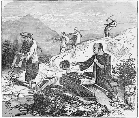
Sonora, the chief camp of the south, was surrounded in close proximity by a larger number of important towns and settlements than could be found elsewhere within the same area. Among them Jackass Gulch bore the palm for yield, and Yankee Hill for nuggets. Chinese Camp, started by an importer of chinese laborers, was long the headquarters for this race. In both counties were stretches of gravel and cognate strata, which about 1855 began to attract attention for hydraulic operations, with ditches measuring 600 miles in length. The line of quartz veins, which soon became the main feature of mining, was bordered on the lower side by the towns of Angel, Carson, and Jamestown, and on the east by Soulsby, whose ledges are among the richest in the country. Thus far extended the mining explorations of 1848, including the most valuable sections of the field. The surface layers along the Merced and Bear Creek, which attracted a considerable number of diggers, particularly below Horshoe Bend on Merced River, and near Quartzburg; but on the Mariposa, Chowchilla, Fresno, and San Joaquin they diminished to small proportions, disappearing in Tulare county. Beyond this they were again discovered in 1853, and led to the brief Kern River excitement of 1854-5. Bank and gravel claims also faded, with a correspondingly decreasing demand for hydraulic methods. The chief wealth of the section consisted of quartz; and although the mother lode tapers rapidly, it still makes a good display in Mariposa, dividing here into two veins which a number of mines opened. This county is entitled to the distinction of the first discovery of such veins in California, on Fremont's grant, in 1849; but development was obstructed, not only by the early obstacles hampering this branch, but by litigation and lack of energy. Kern River revealed several ledges of value, and above there the Sierra Nevada disclosed a large number.
Return To The Main Page: California Gold Rush: True Tales of the 49ers