While the following story discusses one dead river “The Great Blue Lead” geologists have demonstrated that it was not just one but parts of many rivers that are preserved in the gold country of California. Many have at the lowest and richest gold bearing horizon a zone of bluish grey gravel, hence the name “The Great Blue Lead” and the reason early miners assumed (wrongly) that it was just one river.
" What is a dead river ?" The simplest reply to this natural question would be, that a dead river is one which formerly existed, but exists no longer. In volcanic regions it some times happens that the liquid lava, seeking the lowest ground, fills up the beds of rivers which would die, and are replaced by water courses running in other channels, and in different directions. These dead streams are so few and of little importance elsewhere, that as yet, no class-name has been given them; but in California they are among the chief sources of its mineral wealth, and among the most remarkable features of its geological formation. They take us back to a remote era, before the time of 'Borne, or Greece, or Egypt, far back beyond the origin of history or tradition, before our coast had taken its present shape; before the Sierra Nevada had risen to its present elevation; before Shasta, and Lassen, and Castle Peaks, had poured out their lava floods; before the Sacramento river had its birth, and while, if not before, the mastodon, the elephant, the rhinoceros, the horse, the mammoth bull, the tapir, and the bison, lived in the land.
,
They are indeed among the most remarkable discoveries of the age, and among the greatest wonders of geology. They deserve some common name, and we have to choose between ' extinct ' and ' dead.' We speak of ' extinct volcanoes,' and of ' dead languages,' and as the latter is Saxon and short, we preterit. They had been called ' old channels,' but this name does not convey the proper idea, since a channel is not necessarily a river, and an old channel is not necessarily a dead one. A dead river is a channel formerly occupied by a running stream, but now filled up with earthy or rocky matter, and is not to be confounded with a channel that is open and remains dry during the greater part of the year because of a lack of water, or that has been abandoned by the stream for a deeper channel elsewhere. A dry river bed is not a dead river. " The dead rivers of California, so far as known, are on the western slopes of the Sierra Nevada, from five hundred to seven thousand feet above the sea.
They are auriferous, and therefore they have been sought for and examined for gold. They have yielded probably $300,000,000 (15 million ounces) in all; they now produce perhaps $8,000,000 annually. They are not less interesting, therefore, to the miner than to the geologist; not less important to the statesman than to the antiquarian. The largest dead river is known as ' the Big Blue Lead,' and has been traced from Little Grizzly, about latitude thirty-nine degrees and forty-five minutes, in Placer county, a distance of sixty-five miles. The course is south-south-east, the position about thirty miles west of, and parallel with, the main divide of the Sierra Nevada. The elevation is five thousand feet above the sea at Little Grizzly, and two thousand eight hundred at Forest Hill, showing an average fall of thirty-three feet per mile.
The live rivers of the Sierra Nevada run at right angles to the course of the range, and have cut canons from fifteen hundred to three thousand feet deep, and they are separated by ridges which are from three to six miles apart, and are as high as the canons are deep. The Blue Lead runs across these ridges from two hundred to one thousand feet below their summits. The traveler does not see any signs of a dead river in these ridges, which are as high and have the same general appearance at the Blue Lead as at other places. I shall presently tell how the miner discovers the lead, but before coming to that, I want to give you a clear idea how the dead river crosses the ridges. Take a piece of common ruled cap paper; put your pen on a line, draw it up at an angle of forty -five degrees to the second line above, then down the first line at the same angle, and so on until the line made by your pen looks like eight rectangular saw-teeth, which are about an inch high. Consider those teeth, as the ridges of the Sierra Nevada on the line of the Blue Lead in Sierra county, and the intervals between them as the canons. Write over the first canon to the left, 'Canon creek;' over the next, ' Goodyear's creek; and over the others consecutively, 'North Fork of the Yuba river,' 'Rock creek,' ' Oregon ravine,' ' West ravine,' and ' Middle Yuba.' Now draw a horizontal line across all the ridges, a quarter of an inch from their tops. That line is the Blue Lead. The diagram made as directed, represents a perpendicular section of the ridges and canons of the Sierra Nevada, on the line of the Big Blue Lead in Sierra county as seen from the west.
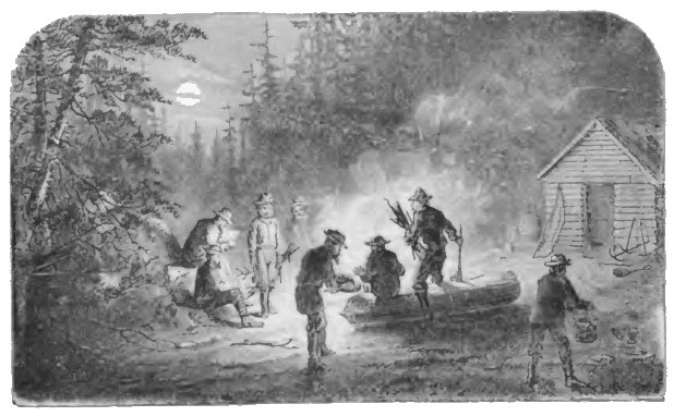
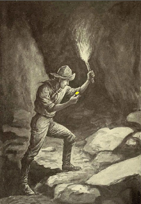
I have said that the traveler would see no sign of a dead river in riding over the country. The ridges are as high on its line as elsewhere; the canon sides present the same appearance. Years elapsed before the miners discovered the existence of the ancient channel. But it required only a few months for the discovery that the live rivers were very rich in gold up to a certain point; that the abundance and size of the particles increased as they ascended up to that point; and that beyond or east of that point the streams were poor. Those points on the different streams were nearly on a line. Just there the ravines on the sides of the canons were very rich, and they were comparatively poor elsewhere. The miners followed up the ravines, washing the dirt in their beds, and the dirt where the ravines were not too steep was a foot or two deep over the slate rock. At last, when the miners got near the top of the ridge, they found that the narrow, shallow rock-bed of the ravine suddenly disappeared, and the body of the hill was composed of gravel, which had a peculiar blue color, and part of it, a horizontal stratum about half a mile wide from east to west, and five feet thick, was very rich in gold. They looked after the metal and paid little attention to anything else. As the stratum ran across the ridges from north to south, the miners followed it in with adits, or tunnels, and in more than one place the tunnels met; and a few years ago it was customary for footmen passing between Monticello and Excelsior to go under ground a distance of a mile rather than to climb over the hill six hundred feet high, by a path nearly two miles long. In the same manner Forest City and Alleghany were connected by a continuous tunnel, but the timbers have rotted, the roof has fallen in, and the passage is now closed.
The auriferous deposit is gravel, mixed with boulders, clay, and sand, varying from a hundred to three hundred feet in depth; in strata, distinguished from one another by differences in color, in the size of the boulders and gravel, and in the number and size of the particles of gold. The predominant color is bluish-gray, dark at the bottom and lighter above, with a reddish tinge in those places that have long been exposed to the air, showing the presence of iron. The material of the boulders, gravel and sand, is almost exclusively quartz. In the whole length of the river, as traced for a distance of sixty-five miles, assuming that the deposits of gravel average half a mile wide and two hundred feet deep, there were, counting in the portions which have been washed away by the live rivers, six billion six hundred and sixty million cubic yards of quartz and clay, and the quartz alone must have measured five billion cubic yards. In the live rivers, quartz forms only a small portion of the gravel.
Whence came all the quartz of the Big Blue? How did it happen that no granite, slate, porphyry, basalt or sandstone was buried in its bed? If all the quartz veins now known in California were cleaned out to a depth of one hundred feet, they would not supply so much as is found in sixty-five miles of a river that must have run for many hundreds of miles. The gravel is all water- worn, and rounded by long attrition. It came from far north. A piece of rough quartz, while being carried five hundred miles in the fiercest of our mountain streams, would not be worn so smooth as is every pebble in the Blue Lead. And the immense size of the boulders implies a mighty current. Those in the lowest stratum average, in some places, a ton. Many are found of twenty tons in size. These are worn as smooth as the pebbles. They are not found scattered here and there as though they had tumbled down the banks of the river near the spot where they are found; but they are evenly distributed in a stratum of equal thickness across the whole bed, and for miles in length. Above that may be a stratum of larger ones. The great river handled these masses of rock with as much apparent ease, and spread them out as evenly, as if they had been no larger than pigeons' eggs." The particles of gold are larger in size, and contain more silver at the bottom than at the top. The smaller pieces are in the upper strata and as they have a larger surface proportionately, the silver is eaten out by the sulphurous acid which is developed in the gravel by the oxidation of pyrites. If a double eagle and twenty one-dollar pieces are thrown into a solution of vitriol arid left there for several weeks, the small pieces will, at the end of that time, contain a larger proportion of gold than the large one; and for a similar reason the surface placer gold is finer chemically than that obtained from the deeper strata. As a general rule, the deep gold is nine hundred fine, or is worth eighteen dollars and sixty cents per ounce, and the surface gold is nine hundred and twenty fine, and is worth nineteen dollars in the Big Blue Lead. The gold and gravel are deposited as in the live rivers, in the banks, bars, eddies, ripples and rapids.
The richest places have contained as much as fifty dollars to the cubic yard of the lower stratum, or if the large boulders were left out of the estimate, to two or three cubic feet. The space between the boulders is filled with sand, clay, and gravel, which contains the gold. In the upper strata there are from fifty cents to two dollars to the cubic yard. The bed is of slate rock, and the banks are from fifty to three hundred feet high; but there are few places where they have been examined, for nowhere has all the gravel been washed away across the channel.
But how was it possible that the bed of a large river could be filled three hundred feet deep with gravel? When the miners in 1850 to 1852, flumed the live rivers of California, and took the gold from their beds, they found a deposit of gravel that did not average more than five feet deep on the bed rock, in streams that ran in canons one thousand feet deep; and it is strange that the Big Blue should have filled its bed with gravel. Yet this filling is not without an analogue of our day. Under the influence of hydraulic washing, Bear river and Yuba river have, within the last fifteen years, begun to fill up with gravel, and their beds have, for miles, risen seventy feet or more above the levels of 1853. This gravel is auriferous, and it is deposited in strata, and the arrangements and general appearance resemble those of the Big Blue Lead. The filling up began down in the valley, and as it ascended the current became less rapid, and lost the power to carry away the gravel. In Bear river, below Dutch Flat, the bed rises two feet per month during the chief washing season, from February to September, and in the remaining months it falls on account of the stoppage of washing and of the Winter floods, which carry off perhaps half of the accumulation of the Summer.
Some persons claim that various camps on parts of dead rivers in Plumas county, are on the Big Blue Lead, and others think that portions of a dead river, near Placerville, belong to the same stream. I do not accept these theories, but if they are true, the Big Blue river has been traced about one hundred and ten miles. In the northern part of Plumas county, the river is buried under deep beds of lava and basalt, and south of Placerville it is probably below the level of the live streams, and thus cannot be found by any system of mining or mode of prospecting now in use. Even in places where it is above the level of the live streams, it may be covered on the sides of the canons by slides of rock or barren dirt or gravel, and the miner might spend thousands of dollars in a vain search for treasures not ten feet from his drift, as many have done, and some accident, luck, or perseverance, afterwards proved the proximity of the rich deposit. In several cases the lead was found by calculation. The miner took his position on a hill-side, on a level with other camps, and in a few days he found a fortune; and others have spent years working on a similar plan without success. The river must have taken bends on the north side of Rock creek and Oregon ravine, and twelve years of searching have not revealed the position of the bends.
But why did the Big Blue river die, and leave nothing but its gravel and its gold to tell the story of its greatness ? The main cause must have been the subsequent rise of the Sierra Nevada. Suppose that a range of mountains, seven thousand feet high were upheaved thirty miles east of the Mississippi; that the bed of the stream were on the mountain side, three thousand feet above the sea, and that thirty miles west the country retained its present level; the result would be that the present Mississippi would soon be a dead river; it would be cut across by streams running down the mountain side, and pouring into a new Mississippi, thirty miles or more west of the present one. We know that the Sierra Nevada has been upheaved; that a large stream ran on what is now the mountain side; and that it has been succeeded by a new river farther west; and we must infer that the death of the old and the birth of the new river was caused by the upheaval.
Many of the hills crossed by the Big Blue are capped with lava or basalt, which covered much of the country from near the summit of the range to about three thousand feet above the sea. It seems then that the river filled its bed with gravel; the mountains began to rise, and volcanoes broke out along the divide; the lava ran down and covered the land to the line of the dead river and beyond it; the mountains rose still higher, and the waters running down their sides cut through the lava and made deep canons, and washed away two- thirds or three-fourths of the dead river, and scattered its gold among the living waters.
The descent of thirty-three feet per mile observed between Little Grizzly and Forest Hill would make a terrific current in a stream half a mile wide. The Sacramento is a lively river, yet its grade is only five feet in a mile. But no ordinary current could have carried the large quartz boulders of the Big Blue Lead from distant regions and distributed them evenly over the river bed. It is possible, however, that in the lifting up of the mountains the relative elevations have been altered, and that the present grade differs from that of the Big Blue while it was alive.
A question suggests itself whether the great dead river was the predecessor of any living stream; but to this no satisfactory answer can now be given; and it is doubtful whether time and research will ever furnish one. The Big Blue was parallel to the Sacramento and has to a certain extent been succeeded by it; but it drained a much larger district than the Sacramento does, or the rain-fall of the country was much greater in the era of its existence. The Sacramento does not carry one-fourth of the water which ran in the Big Blue probably not one-tenth. If we could ascertain that the quantity of rain had not altered, then we should be justified in presuming that the Columbia River, which would just about fill the bed of the Big Blue, instead of turning westward at Walla Walla, originally continued southward, until the lifting up of Shasta and Lassen, and the adjacent ridges, stopped its course, and compelled it to break through the Cascade range at the Dalles. With our present limited knowledge, we are not justified in calling the Big Blue river either the dead Sacramento or the dead Columbia.
Some persons have argued that the Big Blue Lead never was a river, but only a lacustrine or alluvial deposit. This theory, however, is untenable. The Big Blue Lead has all the marks which a dead river should have. It has a long course; a width nearly uniform, a course nearly straight, some bends with eddies on the inner side, a peculiar quartz unlike any found in the neighboring ridges, or in the streams to the eastward, an abundance of quartz, which no place now known to us could have supplied, and which came, probably, from a distant northern region now covered with lava; water-worn gravel, which must have been carried far; flat stones pointing down stream, as a current would place them; strata of coarse and fine gravel, which must have been deposited in a stream; a uniform, descending grade; the coarse particles of gold, which could not have been distributed so evenly over a wide channel except in a strong current; an immense quantity of gold, which required ages to scatter through a deposit three hundred feet deep; drift-wood unmistakably water-worn; trunks of trees with the butts up stream; tributary brooks, and a number of other evidences which would require more space for their description and explanation than I could spare. To say that the Big Blue is not a dead river, is equivalent to saying that the bones of the mastodon never belonged to a living animal, but were formed under geological influences exclusively.
If this were the only dead river in the State, the proof would be less conclusive, but there are a dozen others. One which runs south-westwardly, and may be called the dead Brandy river, appears at La Port, Brandy City, Camptonville and North San Juan, and is marked by the same general characteristics, save that the gravel is finer, the pebbles in the upper strata being generally not larger than a pigeon's egg. In Tuolumne and Calaveras counties we have the dead Stanislaus, or Tuolumne table mountain, which runs from near Silver mountain, in Alpine, to Knight's Ferry, and there disappears. It is covered by a bed of basalt, which flowed as lava from a volcano, and filled up the ancient bed; and this basalt has resisted the elements, and now stands as a mountain forty miles long, a quarter of a mile wide, and eight hundred feet high, the softer adjacent slate rock having been wasted and washed away. Under this mountain lies a dead river, rich in gold.
A similar table mountain of basalt, covering an auriferous dead river, which I call the dead Cherokee, named for its chief mining camp, extends seventy miles, from Lassen's Peak to Oroville. At Bangor, in Butte county, is a small dead river, seventy feet below the general surface of the ground, and covered with ordinary soil and gravel. There are also dead rivers at Smartsville, Mokelumne Hill and San Andreas. The Big Blue and dead Brandy are distinguished by the depth of their gravel, and by the absence of pebbles of eruptive origin in it. The others have either short courses or shallow deposits of gravel; and the quartz forms a much smaller percentage of the gravel. In the dead rivers at Cherokee, Bangor, and Smartsville, a large proportion of the boulders and pebbles is of lava and basalt, as if the stream had been formed after the commencement of the volcanic era. But different as is the material of the gravel, the fluvial origin of the deposits is similar and indubitable in all of them, when they are studied together.
Return To The Main Page: California Gold Rush: True Tales of the 49ers
Finding Gold
