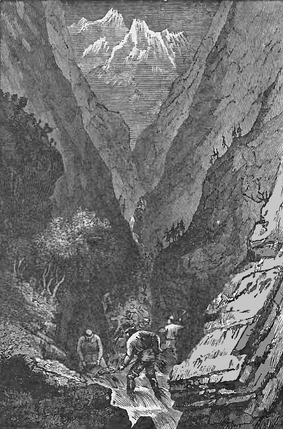
Gold, the lure that drew settlers across the wide prairies and into the most remote mountain gullies in our Western States, proved also to be the dominant factor in the settlement of Alaska. This most important mineral commodity of the State was known in Alaska as early as 1848, long before the territory was acquired from Russia by the United States in 1867. P. P. Doroshin, a Russian mining engineer, made the discovery in the gravels of the Kenai River on the Kenai Peninsula, but there was no great excitement and apparently no gold was mined. A second discovery of placer gold in 1865-66 on the Seward Peninsula by a party exploring for a telegraph route similarly failed to arouse much interest. Alaskan gold mining began in southeast Alaska. In 1869 miners who had been disappointed in the Cassiar gold district in British Columbia discovered gold placers at Windham Bay and Sundum Bay southeast of Juneau. In 1870-71 the first gold produced in Alaska, reported to be worth $40,000, was extracted from these placers. The placer deposits have been found in many parts of Alaska, but the three regions that have yielded the largest amount are the Fairbanks region, the Nome area of the Seward Peninsula, and the Flat area of the Iditarod district. The Fairbanks district is now the leader in gold production.
Gold was discovered in the Forty Mile district of the Yukon in 1886, and this caused a stampede for this region; but the deposits of the Klondike did not become known until 1896, and their discovery was followed by a gold rush of prospectors that eclipsed all previous ones. Indeed, it is said that by 1898 over 40,000 people were camped out in the vicinity of the present site of Dawson. The Klondike region proper is situated on the eastern side of the Yukon River, and the richest deposits found have been on the Canadian side of the boundary. The natural gold has collected either at the bottom of the gravel in the smaller streams tributary to the Yukon, or else in gravels on the valley sides, this latter occurrence being known as bench gravel. The metal is supposed to have been derived from the quartz veins found in the Birch Creek, Forty Mile, and Rampart series of metamorphic rocks lying to the east. Up to the end of 1902 the total production of the Klondike is stated to have been $80,000,000. The annual output has, however, decreased, and mining in that region has settled down to a more permanent basis. In the early days, gravels running under 50 cents per cubic yard could not be worked at a profit, even by dredging, because the difficulties and expenses of mining in such a region are great, and form an interesting comparison with conditions at the same time in California, where gravel carrying 25 cents per yard was considered good, while that running as low as 5 cents per yard could be worked as a dredge proposition.
Since the discovery of the rich gold gravels on the Yukon, auriferous gravels have been developed in many other parts of Alaska, where they were more or less actively worked, but of these various finds those in the Seward Peninsula, which became a very large producer, have been the most important. Somewhat similar conditions exist in some parts of Alaska. Near Nome on the ridges surrounding Anvil Creek are "high gravels" 600 to 700 feet above the present rivers. These gravels, some of which are rich, are the remnants of an old, now almost wholly eroded system of drainage. The first of the localities discovered in the Seward Peninsula region was Cape Nome, which for a time proved to be a second Klondike. The gold was discovered here on Anvil Creek, and the following year in the beach sands where Nome now stands. These discoveries caused another northward stampede, which resulted in the rapid exhaustion of the beach sands; but other deposits were found farther inland near Nome, as well as the other localities on the Seward Peninsula. Some quartz veins are also worked. Up to the end of 1914 the Seward Peninsula had produced $68,642,700 in gold, and in 1906 its production is given as $7,500,000, but by 1914 it had dropped to $2,733,000. So much has been written about the wonderful results of washing the beach sands at Nome for gold and the beach sands proved to be so rich that the impression has prevailed in some quarters that not only has this been the source of the greater part of the gold output of the Nome district, but the Important discoveries in this district arc supposed to have been made first on the beach. This is not quite true, however. The first discovery of gold in the beach sands was made at Sinook, a point about twenty-five miles west of Nome. This led to some prospecting in the vicinity of Nome, but the prospectors were not then fortunate in finding in the beach sand paying quantities of gold, and they proceeded inland, where the first important discoveries were made on Anvil Creek and on Snow and Glacier gulches.
The Nome gold is brighter and prettier than that which is found in the Klondike and assays $2 or so more to the ounce—about $15 to $17 in the one case and $16 to $19 in the other. The greater part of it is in fine particles about the size of the grains of rock salt, or smaller, but a great many nuggets worth from $2 to $7 are also found during clean-up. A nugget was taken from one of these Anvil Creek bench claims which weighed out at over 160 ounces. Late in the season of 1904 a sensational discovery was made on Little Creek, about three miles from Nome and between the city and the center of operations on Anvil Creek. Pans of gravel yielded as high as $135 and one pan is said to have contained ten ounces of gold or $170.
A. J. Collier and F. L. Hess give the following
classification of the placers in Seward Peninsula:
(1) Creek Placers: Gravel deposits in the beds and intermediate flood plains
of small streams.
(2) Bench Placers: Gravel deposits in ancient stream channels and flood
plains which stand from 50 to several hundred feet above the present
streams.
(3) Hillside Placers: A group of gravel deposits intermediate between the
creek and bench placers. Their bed rock is slightly above the creek bed and
the surface topography shows no sign of benching.
(4) River-bar Placers: Placers on gravel flats in or adjacent to the beds of
large streams.
(5) Gravel-plain Placers: Placers found in the gravels of the coastal or
other lowland plains.
(6) Sea-beach Placers: Placers reconcentrated from the coastal plain gravels
by the waves along the seashore.
(7) Ancient beach Placers: Deposits found on the coastal plains along a line
of elevated beaches.
The last great stampede in Alaska followed the lead of a weary and footsore Italian coal-miner, who, deserted by his last companion, and working alone among the hills between the Little Chena and the Chatinka rivers, whose waters flow into the Tanana from the north, hit upon the treasures of what is now known as the Fairbanks District. Felix Pedro sought for gold four summers among the hills and along the creeks of the Forty-Mile district, the Kitchumstock and in the Circle City district, and finally on the banks of the creeks which rise west of the Forty Mile district and flow into the Tanana. Here in July, 1902, he found at last the object of his search. Known as a careful and diligent prospector, his movements were closely watched by others who desired to take advantage of his Industry and his persistence. To avoid revealing the secret of his discovery before he could secure the results of his labors for himself and those who had aided him in his search, he made his camp several miles from the scene of his mining operations, and going secretly each day to his work before and after daylight, cutting his way through the frozen ground without fires, and carrying the waste up a ladder in a sack, he succeeded in locating claims which have since made him and his friends independent of further concern with regard to the fortunes of the miner. During the summer of 1903, the stampede from Dawson into this new gold field threatened to depopulate the metropolis of the Klondike. It is estimated that 3,000 people left Dawson for Fairbanks by the Yukon River.
The placer gold in the Fairbanks district is taken by traders at $16 an ounce. The miners, not satisfied with that price, have had it assayed and find it is worth $17.50, which shows that this is a fine quality of gold, better than that in the Klondike, and nearly as fine as that at Nome. It is more inaccessible, however, than at either of the other places. In the Klondike the gold is often found exposed or very slightly covered along the beds of the creeks. The same is true at Nome. In the Fairbanks district there seems to be no gold in the creek bottoms, but it lies up on the ledges and on the hillsides in a stratum of gold-bearing gravel two or three feet thick, and is located only after sinking shafts 10 to 20 feet from the surface. Occasionally the stratum crops out on the hillside and may be drifted out, as the miners say; that is, tunneled for from the hillside, but in all cases it is frozen and can only be removed after the ground is thawed. While the important placers at Fairbanks were discovered in 1902, it was not until 1910 that lode mines were active in this district. The Fairbanks placers proved amenable to large-scale dredging operations, which soon made this district the largest gold producer in Alaska.
The Fairbanks district lies in central Alaska, where there is a remarkable accumulation of unconsolidated material overlying the bedrock. This material seems to have been deposited in an area where glaciation was absent, but fluviatile conditions predominated. An interesting feature of these deposits is their remarkable thickness, and their depth of consolidation by ice, over 300 feet, as revealed by mining operations. The unconsolidated material includes slide rock, muck, sand, silt, clay, barren gravels, and the gravels in which the gold is found. These productive gravels, so far as discovered, are a thin layer next to bedrock, and the value of the gold recovered has ranged from less than $1 to $8 or more per square foot of bedrock surface. The present activities are supported by low-grade deposits of $1 or less per square foot, and in 1914 deep placers yielding as little as 40 cents per square foot were worked by drifting. The Iditarod district, which produced about $2,000,000 worth of gold in 1914, obtained mostly by dredging, is the third largest producer. A number of smaller districts add to the total supply of the state. As transportation facilities improved after 1900, new gold discoveries were made in the more remote areas, and previously known deposits were developed and mined. This activity extended into the 1930's, and several lode and placer districts in the Yukon basin were activated in this interval.
Continue on to:
Yukon Territory Placer Deposits
Return To:
Important Gold Mining Regions Worldwide