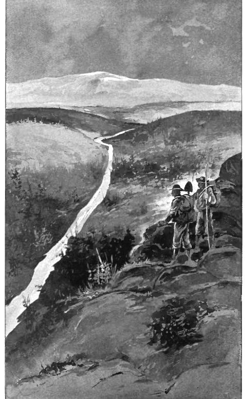
The Klondike gold fields are situated on the east side of the Yukon River at its confluence with the Klondike, and cover an area of about 200 square miles. The district is a part of a dissected upland, and a second uplift in recent times has caused the streams to deepen their valleys, but portions of the old valley bottoms, covered with heavy accumulations of gravel, still remain as benches on the valley sides at many points. Owing to the unglaciated character of the region, the rocks are deeply weathered. The surface materials are permanently frozen. The auriferous gravels occur under the following conditions: (1) Low-level creek gravels, 4 to 10 feet deep, resting on bed rock, and covered by 2 to 30 feet more of black frozen muck. These are the most important; (2) gulch gravels, found in the upper portions of the main creek valleys, and small tributary valleys; (3) gravels on rock terraces, formed during the deepening of the valleys, and representing portions of an old valley bottom; (4) high-level gravels, representing ancient creek deposits, accumulated when the river flowed several hundred feet higher than it does now. Of these the "White Channel" gravels, so called because of their white or light-gray color, are important, and represent the oldest stream deposits of the district. They range in thickness from a few to 150 feet, and are second in commercial importance to the present creek gravels. The Klondike gold varies in fineness, due to its being in all cases alloyed with silver. The lowest grade has a value of about $12.50 an ounce, but some has exceeded $17.50 an ounce.
Gigantic nuggets have not been found in the Klondike, although considerable coarse gold and some larger nuggets have been mined. The official record includes one weighing 34 troy ounces, and another weighing 29 ounces, taken from Claim 36 above, on Eldorado Creek. Another large nugget was found in the Yukon country in 1899 on Claim 34, Eldorado Creek, which weighed over 72 ounces. The heaviest nugget found in the Klondike is said to have weighed 85 ounces. Mnay of the claims produced very rich gravel from the paystreak. On many claims on Bonanza and Eldorado creeks, gravels in the paystreak yielding a quarter ounce of gold per pan were so common that they failed to cause any special comment. Total historical production is 13+ million ounces of placer gold that has been recovered from Klondike placer deposits. The discoverer of the rich placer diggings of the Klondike is known to be George W. Cormack, a working miner, who was generally known as Siwash George, and the first claim was staked on Bonanza Creek, a small tributary of the Klondike River. The staking of this claim occurred on August 17, 1896, and marks the beginning of a wonderful era for The Yukon Territory and Alaska. There are a large number of such creeks as; Bonanza, each said to be equally rich in gold deposits. Among them are the El Dorado, Victoria, Adams, McCormack, Reddy Bullion, Nugget Gulch, Bear, Baker and Chee-Chaw, Ka. This region, which in July, 1896, was comparatively speaking, uninhabited, during the great gold rush was dotted with hundreds of miners' tents, as white as snow.
Important discoveries of gold followed those which were made on Bonanza, El Dorado, Hunker, and Bear creeks. In June, 1897, two men reported gold on Dominion Creek, a large tributary of Indian River having its source opposite Hunker Creek. Both men claimed separate discovery, and the (gold Commissioner, being unable to decide who had the prior right to discovery, allowed two discoveries, which subsequently proved to be five miles apart, and are known respectively as "Upper" and "Lower" Discoveries. The prospects were excellent, but no work of consequence was done until winter. About Christmas reports of half-ounce nuggets being found resulted in a stampede, and everything on the main creek, which was larger than Bonanza, was staked, and staking continued on the numerous tributaries, until, in July. 1898, there were two hundred and evenly-live 500 foot claims on the main creek, which, added to thirty or forty tributaries, reached the extraordinary length of 140 to 150 miles of staked claims. Between Discoveries the ground proved very rich, and single claims were purchased by Eldorado owners for as high as $40,000.
In June, 1897, four men, two of whom were named Whitmore and Hunter, made an important discovery about five or six miles from the head of another large “creek" lying between Dominion and Quartz Creek and heading directly opposite one fork of Gold Bottom. The creek, which was called Sulphur Creek, was staked by successive waves of stampeders. During the winter about a dozen holes were put down at intervals over nine miles of creek, but nearly every shaft disclosed rich pay and demonstrated the creek to be comparable in richness to Bonanza Creek. In July, 1898, over thirty miles of creek and tributaries were staked in 500-foot claims, and those in the best locations were selling for from $30,000 to $40,000. The benches above the rich creeks yielded some spectacular gold as well - on the 10th of March one miner named Joe staked discovery claims, 100 feet square, and his partners the same area alongside. They sank another hole, striking bed-rock at nine feet. Caribou Billy went down into the hole, and, after looking around, called up, "We've got it!" A pan was passed down to him and he sent up three pans of dirt, which were put into a sack and taken down to the creek to pan. The three pans full of gravel in the sack yielded four and a half ounces of gold. Before they could get back up to the hole another "party" had been down into it and found a nugget as huge as his thumb. Joe threw water into the hole and froze it and then recorded the claim. Another stampede of prospectors followed. For some time, the benches continued to be the wonder of the camp. The hillsides for eight miles below and four miles above Discovery, on Bonanza Creek, were spotted with dumps, encircling spots like French Hill and Lancaster's "Gold Hill" like a fillet of gold at a nearly uniform level. Rich bench discoveries were later made on Bear and Quartz creeks, and on Dominion ; the latter, however, being at lower levels than on Bonanza. Running in a direction a little west of northwest through the territory examined is a broad, continuous belt of highly altered rocks, which crosses the natural gold bearing area. To the east this belt is known to be continuous for 100 miles or more in Canadian territory. The rocks constituting this belt are mostly crystalline schists associated with marbles and sheared quartzites, indicating a sedimentary origin for a large part of the series. In the upper part a few plant remains were found, which suggest that this portion is probably of Devonian age. These altered sedimentary rocks have been shattered by volcanic action, and they are pierced by many dikes of eruptive rock.
Throughout these altered rocks there are found veins of quartz often carrying pyrite and gold. It appears that these quartz veins were formed during the disturbance attending the uplift and alteration of the beds. Many of the veins have been cut, sheared, and torn into fragments by the force that has transformed the sedimentary rocks into crystalline schist; but there are others, containing gold, silver, and copper, that have not been very much disturbed or broken. These more continuous ore-bearing zones have not the character of ordinary quartz veins, although they contain much silica. Instead of the usual white quartz veins, the ore occurs in a sheared and altered zone of rock and gradually runs out on both sides. So far as yet known, these continuous zones of ore are of relatively low grade.
In the Klondike, streams have been carrying away the gold from the metalliferous belt for a very long period, so that particles of the precious metal are found in nearly all parts of the area. It is only in the immediate vicinity of the gold bearing belt, however, that the particles of gold are large and plentiful enough to repay working, under present conditions. Where a stream heads in the gold belt, the richest diggings are likely to be near its extreme upper part. In this upper part the current is so swift that the lighter material and the finer gold are carried away, leaving in many places a rich deposit of coarse gold overlain by coarse gravel, the pebbles being so large as to hinder rapid transportation by water. It is under such conditions that the diggings which are now being worked are found, with some unimportant exceptions. The rich gulches of the Forty Mile district, and of the Birch Creek district, as well as other fields of less importance, all head in the gold-bearing formation. A short distance below the heads of these gulches the stream valley broadens and the gravels contain finer gold more widely distributed. Along certain parts of the stream this finer gold is concentrated by favorable currents, and is often profitably washed, this kind of deposit coming under the heading of 'bar diggings." The gold in these more extensive gravels is often present in sufficient quantity to encourage the hope of successful extraction by mechanical dredging.
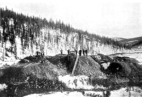
That said 'winter work' is what is known as drift-mining. "That because of the frozen character of the dirt aforesaid, it is the practice to thaw the dirt to be handled, first by means of wood fires to release it from the breasts for hoisting it to the surface, and again by means of the spring sun's heat to free the gold in sluicing." That a fire banked 25 feet in length by 2 feet in height, one half a cord of wood being used, thaws about 5 cubic yards of gravel as it lies in the deposit. At least two men are required to work a creek claim in winter. Thirty cords of wood are required for the winter's burnings of two men. The wood, which grows in the valleys and on the hill-sides, is either procured in the summer or fall before drifting begins, or as needed from day to day. Drifting begins in late September, as soon as the surface water of the creeks is in a measure dried up by tin- frost. Contrary to a prevailing notion, the colder the weather, the better for winter work.
When the miner is ready to place his first fire, he judges as well as he can where the pay streak is, but in this he has absolutely no surface indications to guide him. The fire is put in at night and in the morning the smoke has sufficiently cleared to allow a man to go into the hole. The smoke is very trying to the eyes, and not infrequently gases in the hole have overcome and killed the miner. The common manner of "proving" a claim consists of sinking to bed-rock, and drifting on bed-rock across the creek; but if the creek should be "spotted," it may be necessary to "cross-cut" more than once. When the pay streak has been found it is followed by a series of holes and drifts up and down. In order to know when he is on the pay streak the miner will make tests each day (perhaps several times a day) where he takes one or more pans of dirt from the hole and pans it out in a wooden tank of water in the cabin, carefully weighing the gold thus found. In April and May preparations are begun to sluice the dumps, by building a dam exactly as for summer sluicing. The water is led in a three-foot flume along the dumps and the material shoveled into it "The ' summer work ' consists in opening pits or cuts (opencast mining) and sluicing the gravels.
Continue on to:
Placer Gold Mining Districts Of British Columbia
Return To:
Important Gold Mining Regions Worldwide