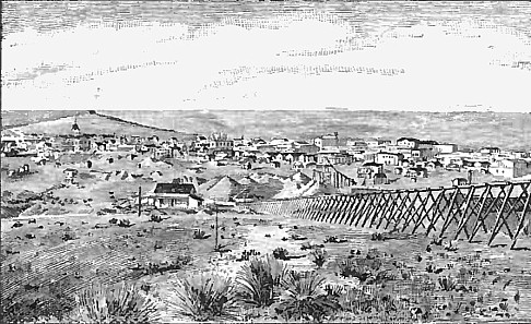
TYNDALL DISTRICT
This district lies upon the west side of the Santa Rita Mountains, and
extends from the Rio Sonoita northward a distance of eighteen miles, a very
small section of the area being in Pima County. The width of the
district is about six miles. The region is rough and rugged, the three
highest peaks of the Santa Ritas (Mount Hopkins, Old Baldy and Josephine
Peak) being at the north and east edges of the district, and the surface of
the entire district is cut deeply by the canyons and gulches draining their
slopes. Elevations vary from 3,500 to 9,000 feet. Geologically the district
embraces a wide variety of formations, and the ore occurences are extensive.
The Tyndall District was the seat of some of the earliest mining of which
there is any record on the Pacific Slope of the United States, cited in the
opening pages of this bulletin ; the Jesuit missionaries at Tumacacori
having discovered and wrought the Salero, Alto, Montosa, Wandering Jew, and
other properties as far back as 1688. American operation began with
acquisition of the Gadsden Purchase in 1856. The district embraces forty or
more mines or groups of mines, many of them presenting extensive development
and operations proceeding actively in quite a number. They include the Alto,
Apache, Arizona-Pittsburg, Aztec, Blacksmith,
Bland, Bradford, Burro, Camp Bird, Connecticut, Conquest Group,
Devil's Cash Box, Elephant Head, Eureka, Hermit's Home, Ivanhoe, John Allen,
Joplin, Jumbo, Mary & Poltski,
Montezuma, Montosa, M. & S., Rhode Island,
Rosario, Royal Blue, Salero,
Santa Rita, Sheehy Group, Tia Juana, Toluachi Group, Treasure Vault,
Trenton, Wandering Jew, Vulcan, etc.
ALTO MINES
These present an extensive development and have been very richly productive.
The ground included was among the early discoveries of the Jesuits, who are
said to have continued operations in their primitive and desultory way
rather steadily for about 150 years. Their facilities for development, ore
extraction and reduction were crude and ineffective. Drill steel and
blasting powder were unknown. With rough iron bars they drilled to depths of
several feet into the rocks large round holes several inches in diameter,
which were filled with lime, plugged securely and water poured in. The
swelling lime rent the rocks, and when thrown out of place they were broken
further with hammers. That process necessarily must have been slow and
painful.Ores were packed to the surface on the backs of men, carrying rude
rawhide buckets, climbing out of shafts on rude ladders, poles with notches
cut into them.
Ores were smelted in rude reverberatory furnaces that were made from adobe, and after reduction the lead and silver ore were separated by a rude cupelation in the same furnace. In other regions where the ores carried gold and silver only the rock was milled with mercury in arrastras, and the amalgam retorted crudely. Processes so crude were slow and laborious. They were possible only with a laboring population but little better than slaves, with wants limited and contented with a bare subsistence. The property is located in the Salero region, about eight miles east from the Santa Cruz River, at Tumacacori, where are to be seen the ruins of the mission that was the home of the mining monks. About 1875 Mark Lulley, now of Nogales, located a part of the ground under the name of the Goldtree Mine. He sold it and there was taken out a great deal of high-grade lead-silver ore in the upper workings. A dozen years ago the property was made over to the Alto Mining Company, under which there was done a great deal of work, and that company was succeeded by the Santa Cruz Smelter, Mines & Transportation Company. Now the ownership is a subject of a complex litigation. There are about 10,000 feet of work, several tunnels, with crosscuts, shafts, drifts, winzes, etc. The ores in the lower workings are copper bearing. The geology of the Alto hill is complicated, and a description would require too much space to serve the purposes of this bulletin.
SALERO MINES
About three miles south from the Alto are antiguas also, wrought by the
Jesuits long, long ago ; and it was one of the first to which attention was
turned after American occupation sixty years ago, there clustering about it
traditions of some of the tragedies of Apache hate and ferocity. Until
recent years it was in operation, a steady producer of high-grade lead and
silver ores, but the death of the chief owners, following each other closely
some years ago, caused suspension of operations, and the property stands
idle.
WANDERING JEW
This group of mines is north from the Alto, on the next ridge. In the
principal ledge there is considerable development, with a fine showing of
lead-silver ores, manifesting the usual tendency to run into
copper ore, the copper content increasing steadily as depth is
attained. The Jew is in the same ledge as the Lee shaft in the Ruby Mine, on
the east side of the main ridge, from which the Jew ridge is a spur, the
ledge being traced readily across the mountain down the other side. The
collar of the Lee shaft is lower in altitude than the deepest work in the
Wandering Jew, and at a depth of 400 feet the Ruby is distinctively a copper
producer. In the Wandering Jew the ore chutes are strong and well defined.
With more depth they are apt to yield a good copper output. The owners of
the Wandering Jew are Mark and Louis Lulley of Nogales, with R. R.
Richardson of Patagonia. The property is under bond and lease to Holt Brothers, experienced
operators, who have scored several successes in
Mexico. They are shipping ore.
TOLUACHI GROUP
This mine is north from the Wandering Jew, owned by Mr. Josiah Bond,
includes the Jersey Girl, Silver Sally and Merry Widow. The principal work
is on the Silver Sally, which has a shaft nearly 300 feet deep with a level
at 220 feet. The ledge is about fifteen feet in width and has yielded ore
that has averaged fifty ounces silver per ton. The Merry Widow has a shaft
100 feet in depth, operating a vein from which ore shipments yielded 8% lead
and 72 ounces silver per ton.
BLAND MINE
This location is in the immediate vicinity of the Alto, lying southeast.
Tunnels are the principal development, the lowest being 540 feet below the
croppings, the aggregate work being 1,500 feet. Near the surface the ores
were high-grade lead-silver, carrying copper; but with depth the lead
diminished. In the early history of operation two carloads of ore shipped to
El Paso and treated yielded 64% lead, 24% copper and 35 ounces silver per
ton.
Assays taken later from lower levels are reported to have run 8% to
12% copper, 6 to 15 ounces silver and $3 to $12 gold. Upon the two dumps
there are measured 300 and 500 tons of ore, respectively, which show good
values in copper,
native gold and silver. The Bradford,
Rosario, Montezuma, and other
good properties are at the south end of the district, near the Rio Sonoita.
In the northern end of Tyndall District are the Devil's Cash Box, Sheehy
Group, Conquest Group, Elephant Head and other properties. Old Baldy and
Greaterville Districts, on the north side of the Santa Rita Mountains, lie
for the most part in Pima County, but the southern tips of
each being in Santa Cruz. In Old Baldy District are the Curry properties,
worked by the Six Metals Mining Company, running a concentrator and shipping
copper concentrates. The Greaterville District is chiefly gold bearing, with
good quartz ledges and extensive placer deposits. Some of the placers are on
the Santa Cruz side of the line.
Southwest from the Greaterville settlement, but within the County of Santa Cruz, lies an extensive deposit of onyx, owned by the Onyx King Mining Company. The stone is very pure, beautifully colored and susceptible of a high polish. San Cayetano District covers San Cayetano Mountain, between the Santa Rita Mountains and the Santa Cruz River. It embraces the Tubantia Mine, the Wise Prospect and some undeveloped gold ore ledges. From the Tubantia there has been shipped some ore. In the region west of the Santa Cruz River the Atascosa Mountains are divided into three districts the Sopori, covering the north end of the main range, the Pajarito District, on the south end, abutting on the Mexican line, and the Oro Blanco District, in outlying spurs on the west. In the Sopori District there is some prospecting, and in the Pajarito are the Raines Group, Clarke Group and Maloney Group of mines. In none of them is there anything doing.
Return
to The Arizona Page:
Arizona Gold Rush Mining History