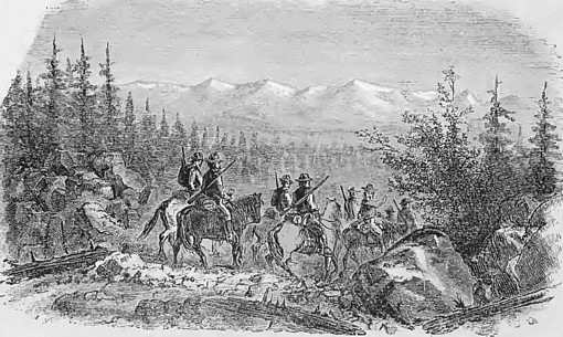
Gold was reported from British Columbia as early as 1850, but important deposits were not found in the region until 1857, when the first discoveries of the rich gravels of the Fraser, Thompson and Columbia Rivers were made. This precipitated a gold rush drawing miners mostly from California. This rush was short lived, but enough of them remained behind to create the core of the Crown Colony. By 1868, the principal production was still from the Fraser and its tributaries, principally from Williams and Lightning Creeks in the Cariboo district. In 1872, the rich deposits of the Cassiar district at the head waters of the Dease River were found, and they have since yielded large amounts of alluvial gold. Additional great discoveries at Granite Creek and Similkameen were also made shortly there after.
The auriferous streams of the Cariboo district lie for the most part within a radius of 20 miles from Barkerville. The area forms a portion of the watershed of the Fraser, being drained by its tributaries, the Quesnelle, Cottonwood, and Willow rivers. The alluvial gravels have been in the past exceedingly rich, quite as much so as the better-known gravels of the Yukon. Williams Creek, Cariboo district, is reported to have yielded upwards of a quarter million ounces from a length of 2| miles of stream bed. Lightning Creek has been quite as rich. The bed-rocks of the region are the crystalline Cariboo schists of Lower Palaeozoic age, and the schists contain low-grade pyritous gold-quartz veins with a little galena. The sulphides themselves occasionally carry high values in gold, but in no vein yet discovered has gold been found comparable in size with the coarse nuggets of the gravels. In one vein alone, viz., Perkins Ledge on Burns Mount, has free-milling gold-quartz been seen. The Cariboo schists, especially along vein fissures, are often graphitic.
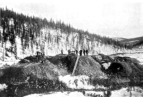
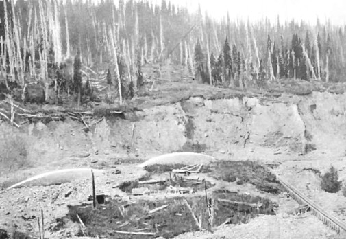
Most of the gold mined from Cariboo has come from benches above the present rivers, through hydraulic mining methods. The gold of the richer streams, Williams, Lightning, Lowhee and Grouse is exceedingly coarse. The largest nugget taken from Lightening Creek was found on the Butcher Bench and weighed about 40 ounces. The gold nuggets in the rich shallow creek-deposits vary greatly in appearance in different creeks, and even in different parts of the same stream. Nuggets from the higher reaches are generally large and angular, but become smaller and smoother as they descend the streams. Quartz boulders containing both gold and pyrite have been found in the wash. The Cariboo gravels are now wholly worked by large companies.
The Atlin division of the Cassiar district is in the extreme north of British Columbia, and its auriferous streams flow into Atlin Lake from the east. The earliest recorded discovery was made on Pine Creek early in 1898 by McLaren and Miller. Old and rotted sluice boxes have been found in the neighborhood, and it is commonly believed that the deposits were known prior to that year. The bed-rocks of the gold-bearing gravels are the "Gold Series" of Gwillim. a They are Palaeozoic slates, actinolite- and biotite-schists, and magnesian rocks (dunite, peridotite, magnesite, serpentine), together with younger greenstones (andesitic). In Pine Creek valley are numerous diabasic dykes and some small areas of diorite which may be related to the greenstone. The schists occur only near the granite contact. Well-defined pyritous quartz veins cross the slates of the Gold Series. While their tenor in gold is low, it is probably from them and from the auriferous pyrites of the biotite-slates that the gold of the streams has been derived. An interesting occurrence of gold in the pyritous biotiteslates is reported from Wright Creek, falling into Surprise Lake. Here the stream flows over heavily mineralised slates and gold is found deep down within the bed-rock. It is not clear, however, whether the gold is alluvial and has sunk into crevices, or whether it is derived from the decomposition of the pyrites. The latter is, however, probably the case. A similar area of auriferous pyrite bearing rock crosses Pine Creek, near Willow. Gwillim concludes that the placer gold is derived from the country rather than from the veins. The auriferous alluvial belt lies to the east of Atlin Lake, and covers an area of 150 square miles. The gravels are pre-glacial, glacial, and post-glacial. The first are the richest, though local concentrations may occur in the last. The old gravels of Atlin are in a state of advanced decomposition, appearing as shining pebbles in a paste of yellowish mud. Most of the gold found there lies on bed-rock or within 8 feet above it. The grains are for the most part coarse, and of the size and shape of flax seed. The largest nuggets yet found there have been 83 ounces (with some quartz), 36i ounces, and 28| ounces respectively. The principal creeks now being worked are Pine, Spruce, Willow, Birch, Boulder, and McKee. All the gravel, whether moved by steam-shovel, or otherwise, is sluiced.
Other mining divisions of British Columbia of less importance, in which placer gold is being recovered, are the Liard, Stikine, and Skeena, south and south-west of Atlin, and with geological conditions similar to those of Atlin; the Lilloet division, along the benches of the Fraser river and in Bridge river and Cayuse Creek ; and the Fort Steele division of East Kootenay. In the last-named the first alluvial discoveries were on Wild Horse Creek, joining the Kootenay at Fort Steele. This stream is reported to have yielded for two years 1 to 10 ounces of gold per man per day. It was worked out by the end of 1866. The yield of placer gold in British Columbia for 1907 was 169,740 ($828,000), while the total value of the placer yield from 1852 to 1907 inclusive has been 3.5 million ounces.
Although alluvial gold has been worked in the province since 1858, the lode mines were discovered much later, in the 1890s. The majority of the reefs are admittedly low grade, and usually of a highly refractory sulfide nature, so they were difficult for the early miners to work. The important gold lodes of the province are all situated in the south and the south-east, generally only a few miles north of the international boundary. Of these, the best known are those of Rossland, five miles north of the boundary, in the West Kootenay district. The town and mines are on Red Mountain at the head of Trail Creek, and are at an average altitude of 3,140 feet above sea-level. The lodes were found in the summer of 1890, all the principal mines of the present time being staked on the same day. One mine which eventually proved to be the richest was given away for the price of the recording fees ($12.50). The field suffered for several years from lack of transport facilities, but in 1896 it was connected by railway with the outside world.
The Rossland ore-bodies
may occur in any of the country rocks, with the exception of the later
dykes. Augite-porphyrite and the coarser grey granitoid rocks (monzonite)
are the most favorable. All the proven productive zones are situated near or
between exposures of alkali-syenite (alaskite). The remainder of the
stratified rock is mineralized, but too diffusely to be of economic
importance. The ore deposits occur in fissure veins formed by fracture, or
by fracture and replacement, and also in zones of Assuring and shearing, in
which the ore is found in a close network of veinlets. The two foregoing
have furnished the more important ore-bodies, but irregular impregnations in
the country are also met with and are worked. The gangue is mainly country,
with occasional
quartz and
calcite.
The ores occur :
(a) As massive pyrrhotite and chalcopyrite with
pyrite and arsenopyrite. Free
natural gold, though rarely
visible, occurs in this matrix, as also does
galena and
sphalerite. Small quantities of nickel and cobalt are
at times recognized.
(b) As massive pyrrhotite with very little copper and gold.
(c) As pyrite, marcasite, and
arsenopyrite veins with occasional argentiferous galena and
sphalerite.
(d) As impregnations of arsenopyrite, pyrrhotite, pyrite,
molybdenite,
chalcopyrite, bismuthinite, and
native gold, especially in the neighborhood of pegmatitic or aplitic
alkali-syenite dykes.
(e) As gold-bearing quartz
veins.
In typical British Columbia gold ores the highest value is in gold, followed by copper, and then by silver. The proportion of free gold does not appear to diminish in depth, nor does the gold accompany any specified mineral, though in some places an increase in the amount of chalcopyrite denotes an increase in gold tenor. The chief lodes of Rossland are the Le Roi Centre Star, Main, South, and Josie. Sharply denned walls are lacking, and the width of a lode is determined often only by economic considerations. Within the lodes, shoots or pay-streaks, often lenticular and of great size, furnish much of the ore, and are most common when the lode is intersected by faults and dykes.
Continue on to:
Gold Deposits of Victoria, Australia
Return To:
Important Gold Mining Regions Worldwide