The Pacific Coast Belt. California is the largest producer of copper in this western belt. The most important copper-bearing region of Shasta County, is in the Klamath Mountains, a few miles north of Redding near the northern end of the Sacramento Valley. Here the copper ore occurs in Permian-Carboniferous and Triassic lavas and tuffs. The ores are of the sulfide type and the lodes vary from a few inches to hundreds of feet in width. A second important field lies in the foothills of the Sierra Nevada Range.
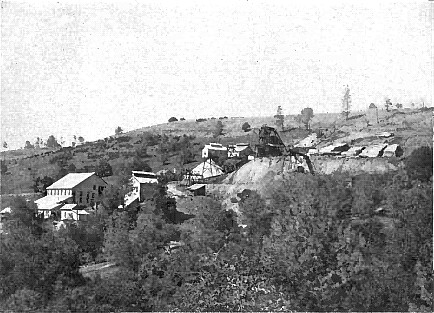
Copper Deposits of Shasta County, California. - The Shasta copper-zinc belt is in west-central Shasta County in the foothills of the Klamath Mountains and a few miles north of Redding. The two main areas of mineralization are known as the West and East Shasta districts. Part of the East Shasta district has now been inundated by the waters of Shasta Lake. Gold and silver-bearing gossans were originally mined in these districts during the 1860s. Later, from the 1890s to about 1920, copper and zinc ores were mined in large quantities and treated in several nearby smelters.
The copper deposits which have been actively mined and smelted since 1895 are found in a number of districts in Shasta County, California; among the more prominent mines are the Iron Mountain, Bully Hill, Mammoth, and Balaklala. The production of copper in 1917 was 26,700,000 pounds. The sedimentary rocks consist of Devonian and Carboniferous closely folded slates and contain intrusions of a highly siliceous and sodic alaskite porphyry, which is the country rock of almost all the important copper deposits. Somewhat later than the alaskite porphyry, but belonging to the same (early Cretaceous) period of intrusion, is a quartz diorite, probably equivalent to the granodiorite of the Sierra Nevada. No copper deposits occur in the quartz diorite, but it contains workable gold-bearing quartz veins. Deep erosion has taken place since the period of intrusion; Graton estimates the depth of rocks removed as not less than 5,000 or 6,000 feet. The rocks have been subjected to some shearing and brecciation, but little extensive dynamo-metamorphism, since the intrusion.
The copper deposits were formed during the interval between the two epochs of intrusion. The copper ore bodies are large, irregular tabular masses of pyrite with some chalcopyrite; single ore masses have dimensions of 1,200 feet in length, 300 feet in width, and nearly 300 feet in thickness, and some of them contain many million tons of ore; the Iron Mountain mass before a great part of it was converted to gossan probably contained 20,000,000 tons of ore, exclusive of the large mount which has been removed by erosion. Chalcopyrite, chalcocite and bornite occur in the Iron Mountain district as impregnation deposits in a zone of crushed breccias in rhyolite. Chalcopyrite, pyrite, quartz and barite occur in the Bully Hill district in a sheared zone following a dike of diabase. The ore lies either in the dike or at the contact with rhyolite.
Many of the bodies lie flat and are easily accessible by tunnels. The ores contain chiefly pyrite with about 3 per cent, of copper as chalcopyrite, and as much as $2 per ton in gold and silver, about equally divided between the two metals. Sphalerite is present in varying amounts, and the ore contains a little bismuth, arsenic, and selenium. The gangue minerals include quartz, calcite, barite, gypsum and anhydrite; the succession is in general pyrite (oldest), sphalerite, chalcopyrite, quartz, and barite. There is a deep oxidized zone with sulfide enrichment. The deposits are mineralogically simple. Pyrite is the most abundant mineral, and chalcopyrite is the chief copper mineral. The gangue minerals are gypsum, calcite, and barite. The minerals that have resulted from the alteration of the primary copper ore include limonite, wad, chalcopyrite, bornite, chalcocite, cuprite, native copper; malachite, azurite, and several sulfates. Some of the deposits contain considerable sphalerite. The alaskite porphyry near the ore-bodies is more or less altered and contains sericite (probably also paragonite), secondary quartz, chlorite, pyrite, carbonates, and epidote. Cogent evidence is cited by Graton that the pyritic ores are replacements of the surrounding porphyry in sheared and brecciated zones. This replacement is believed to be due to hot solutions emanating from the cooling alaskite porphyry. The action of surface waters in the ore deposition is probably negligible, for at that time the alaskite porphyry was everywhere covered with a blanket of impermeable shales. Substantial amounts of by-product gold were recovered in these operations, especially in the West
Shasta district. For example, the Mammoth mine, during the period of 1905 to 1925, yielded 132,510 ounces of gold from zinc / copper ore at an average of .039 ounces of gold per ton. During the 1930s substantial amounts of gossan were mined for gold near the Iron Mountain mine. The total gold output of the West Shasta district is estimated at 520,000 ounces. The total production of the East Shasta district is unknown, but during the period 1900-52, the district was credited with an output of 44,000 ounces of gold. The ore deposits consist of either bodies of massive pyrite with varying amounts of chalcopyrite and sphalerite in rhyolite or sulfide minerals disseminated in schist. Veins or replacement deposits exist in schist and limestone. Most of the massive sulfide bodies are lenticular and range from a few tens of feet long to one at the Iron Mountain mine that is 4500 feet long. The gold content of these deposits usually ranges from .01 to .1 ounce per ton.
In the Klamath Mountains of Shasta County, there are important replacement deposits of pyritic copper ore occurring mainly along fissures and shear zones of an intrusive Mesozoic alaskite porphyry. Two areas separated by the Sacramento River are recognized. An eastern one, containing the Bully Hill and Afterthought districts, with deposits more vein-like, the ore siliceous, relatively high in chalcopyrite, and sphalerite important. A western one, with more or less flat, tabular ore bodies, carrying pyrite, some chalcopyrite and variable sphalerite, the last being sometimes rich enough to form zinc ore. The gangue is gypsum, calcite and barite, and while chalcocite and bornite are sometimes found intergrown with chalcopyrite, they may at times be secondary. Good gossans are found. Magmatic waters are supposed to have deposited the ore in the highly sericitized alaskite porphyry.
California: The Sierra Nevada Foot Hills copper belt, occupying a somewhat extensive area west of the mother lode gold belt, carries pyrite and chalcopyrite lenses in schistose rocks. The ores at times carry considerable lead, zinc and precious metals. It is a discontinuous belt of copper and zinc mineralization, but has also been the source of substantial amounts of gold. Gold bearing gossans in the oxidized zones overlying the copper-zinc deposits were mined during the gold rush. Later, during the copper "booms" of the Civil War and World Wars I and II, considerable amounts of gold were recovered as a by product of copper mining. During the 1930s a few goethite gossan deposits in this belt were again mined for gold. The primary copper and zinc deposits consist of lenticular sulfide bodies in zones of alteration in greenstones and various types of schists. The copper ore bodies contain abundant pyrite with associated chalcopyrite, sphalerite and some gold and silver. Most of the ore contains only a small fraction of an ounce of gold per ton, but a few ore bodies have yielded as much as one ounce of gold per ton. Also present are galena, bornite, tetrahedrite, covellite, and chalcocite. The most important mines in the foothill belt have been the Big Bend mine, Butte County, Spenceville and Boss mines, Nevada County; Dairy Farm and Valley View mines, Placer County; Copper Hill and Newton mines, Amador County; Penn, Quail Hill, Napoleon, Collier, Keystone-Union, and North Keystone mines, Calaveras County; Blue Moon, Pocahontas, Green Mountain and La Victoria mines, Mariposa County; Buchanan, Jessie Belle, and Daulton mines, Madera County; and Fresno Copper and Copper King mines, Fresno County.
Considerable by-product gold has been recovered from copper mines in northeastern Plumas County, the principal sources having been the Walker, Engels, and Superior mines. However, few production figures are available, so the total gold output of these mines is unknown. In 1931, the Walker mine was the source of 432,000 tons of copper ore that had an average gold content of .05 ounces per ton. At the Walker mine, the ore bodies consist of chalcopyrite bearing quartz veins in schist and hornfels near granitic rocks. At the Engels and Superior mines, the copper ore bodies are bands of chalcopyrite and bornite in sheared granitic rocks.
Return To: Copper Ore Deposits of the USA


